Chkhorotsqu Municipality

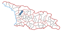
Chkhorots'q'u (Georgian: ჩხოროწყუს მუნიციპალიტეტი, Çxoroċqus municiṗaliṫeṫi) is a district of Georgia, in the region of Samegrelo-Zemo Svaneti. Its main town is Chkhorots'q'u.
Population: 30,124 (2002 census)
Area: 619 km²
Administrative divisions
Chkhorotsqu municipality is divided into one borough (დაბა, daba) and 12 villages (სოფელი, sopeli):[1]
Boroughs
Villages
- Mukhuri
- Zumi
- Taia
- Khabume
- Kvedachkhorots'q'u
- Lesich'ine
- Lets'urts'ume
- K'irtskhi
- Nak'iani
- Akhuti
- Napichkhovo
- Ch'ogha
See also
References
- ^ "ჩხოროწყუს მუნიციპალიტეტის საკრებულო". www.chkhorotsku-sakrebulo.ge. Archived from the original on 2017-02-27. Retrieved 2017-02-27.
External links
- Districts of Georgia, Statoids.com
42°30′37″N 42°07′45″E / 42.51028°N 42.12917°E
