
Bedrock mortar

A bedrock mortar (BRM) is an anthropogenic circular depression in a rock outcrop or naturally occurring slab, used by people in the past for grinding of grain, acorns or other food products.[1] There are often a cluster of a considerable number of such holes in proximity indicating that people gathered in groups to conduct food grinding in prehistoric cultures. Correspondingly the alternative name gossip stone is sometimes applied, indicating the social context of the food grinding activity. Typical dimensions of the circular indentations are approximately 12 centimeters in diameter by 10 centimeters deep, although a considerable range of depths of the cavities have been documented .[2] The bedrock mortar has been identified in a number of world regions, but has been particularly intensely documented in the Americas. An alternative term for the bedrock mortar site is bedrock milling station.
Bedrock metate
A bedrock mortar should not be confused with a bedrock metate, which is a flat, trough-shaped depression often found with bedrock mortars.[3]
Example locations of occurrence
- Southern Arizona: In the Santa Catalina, Santa Rita, Rincon, Sierrita, and Tucson Mountains, and also in rock outcroppings in the valleys
- Along the north banks of the middle reaches of the Merced River in Mariposa County, California, United States [4]
- In Santa Barbara and San Luis Obispo counties on the California Central Coast [5]
- In northern Mexico within the Sierra Tarahumara of Southern Chihuahua[6]
- The Upper Cumberland Plateau of Tennessee, United States
- Inside many rock shelters in Menifee County, Kentucky, United States
- The Cueva de los Corrales region of northwestern Argentina [7]
Gallery
-
 Natufian bedrock mortars at Mount Carmel, Israel.
 -
 Maidu bedrock mortars in northern California.
 -
 Bedrock mortars at the Anza-Borrego Desert State Park in southern California.
 -
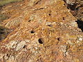
 Bedrock mortars used to grind acorns in California.
 -
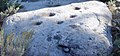
 Hohokam bedrock mortars at Indian Kitchen, Arizona.
 -
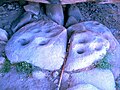
 Bedrock mortars at Huerfano Butte.
 -
 A close up view of a bedrock metate at Huerfano Butte.


See also
Line note references
- ^ "Archaeology online glossary". Archived from the original on 2007-07-01. Retrieved 2007-07-02.
- ^ Discovering Prehistoric Sites: Objective and Subjective Survey Techniques, Daniel G. Foster, Brian D. Dillon, and Linda C. Sandelin, California Department of Forestry and Fire Protection, June 13, 2005
- ^ "Cultural Resources of the Santa Rita Experimental Range" (PDF). John H. Madsen. Retrieved 4 December 2013.
- ^ G. Deghi, J. Buxton et al., Earth Metrics, Environmental Impact Report for the Saxon Creek Water Project, Mariposa County, California, published by the County of Mariposa Planning Department and Mariposa County Water Agency, Report 10298, May, 1990
- ^ http://yankeebarbareno.com/2012/07/05/stumbling-upon-chumash-bedrock-mortars/
- ^ "C. Melvin Aikens, Cultural Continuity in the Sierra Tarahumara of Southern Chihuahua, Mexico, June 2003". Archived from the original on 2007-05-27. Retrieved 2007-07-02.
- ^ M. Del Pilar Babot, María C. Apella, Maize and Bone: Residues of Grinding in Northwestern Argentina, Archaeometry, Volume 45 Issue 1 Page 121-132, February 2003