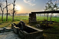
Saleem Khan
Saleem Khan Khel | |
|---|---|
 | |
| Coordinates: 34°10′N 72°28′E / 34.17°N 72.47°E | |
| Country | |
| Province | Khyber Pakhtunkhwa |
| District | Swabi |
| Government | |
| • Nazim | Malik Gulzar Khan |
| Area | |
| • Total | 19.43 km2 (7.50 sq mi) |
| Population (2012) | |
| • Total | 28,000 |
| • Estimate (2017) | above 40,000 |
| Time zone | UTC+7 (PST) |
Saleem Khan or Saleem Khan Khel is a town and Union Council of Swabi District in Khyber-Pakhtunkhwa, Pakistan.[1] The village is 2 kilometres (1.2 mi) to the south of Buner District at an altitude of 348 metres (1,142 ft).[2]
Demographics
The village is divided into two major chams/groups : Behazad Kheil and Mir Ahmed Kheil. Each group has different clans/tribes. The Behzad kheil cham includes Behzad Kheil, Ghurghashti (Khan Kheil), Sudo kheil, Dewaan Kheil etc., while the Mir Ahmed Kheil cham includes Shah Khan Kheil, Kamral, Yara Kheil and Kandar Kheil,Bagarh.(باگڑ)
Ghurghashti originally known as Khan Kheil (غرغښتي) is a tribe there. Historically Ghurghasht (غرغښت) is the third son of Qais Abdur Rashid, that founding father of the Pashtun nation who lived in the times of Khalid Bin Waleed.
Gharghashti (غرغښتي) is an early term for Pashtun.
More than 40,000 people live in Saleem Khan (according to an unofficial of 2017 national census).[when?] The population of the village is increasing rapidly.[citation needed]
Geography
The Stefa canal crosses outskirts of the village. The canal goes underground for almost three kilometers.
Economy
Inhabitants mostly depend on agriculture. Crops grown include wheat, maize, sugar cane, peas and tobacco. About 50% of the youth work overseas, especially in the United Arab Emirates, and the town is dependent on remittances from these overseas workers.[citation needed]
Surroundings
Outskirts of the village include Kaglaich, Abo Banda, Janak, Major Banda, Abbazo, Palodand, Karra, Khadi Mera, Chapai, Bakar and Petai.
Saleem Khan is surrounded by other villages, including Maneri (south), Gohati (west), Dagai (East) Totalai (north) and Naro (southwest).
Politics
It has three electoral wards: main village (Saleem Khan Khas) Bakar and Palodand.
Education
The literacy rate is 80-85% at primary school age, 60-65% at secondary school age and at college age these values are very low because every year young people leave the country to work. Thirteen primary schools for boys and nine primary schools for girls, one high, one middle school for boys & one higher secondary school for boys and one high school and two middle schools for girls are located there. Five private schools work there.[3] Six large and many small Islamic maddrasas are there, producing many Hufazi kiram and Ulema e kiram.
See also:
- Swabi District
- Slam khan is a compound word of the Pashto, Germanic and Vedic languages. Slam khan is a locative noun with absolute topographical and functional meaning. it's never been a Saleem khan. With the reference of toponym, Slam Khan is the adjectival form of the specific place-name.
References
- ^ Tehsils & Unions in the District of Swabi - Government of Pakistan Archived 2012-02-09 at the Wayback Machine
- ^ Location of Salim Khan - Falling Rain Genomics[permanent dead link]
- ^ According to elementary and secondary education district swabi

