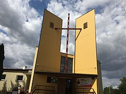
Szymankowo
Szymankowo | |
|---|---|
Village | |
 Saint Florian church | |
| Coordinates: 54°4′23″N 18°55′23″E / 54.07306°N 18.92306°E | |
| Country | |
| Voivodeship | Pomeranian |
| County | Malbork |
| Gmina | Lichnowy |
| Population | 768 |
| Time zone | UTC+1 (CET) |
| • Summer (DST) | UTC+2 (CEST) |
Szymankowo [ʂɨmanˈkɔvɔ] (German: Simonsdorf) is a village in the administrative district of Gmina Lichnowy, within Malbork County, Pomeranian Voivodeship, in northern Poland.[1] It lies approximately 5 kilometres (3 mi) south of Lichnowy, 9 km (6 mi) north-west of Malbork, and 38 km (24 mi) south-east of the regional capital Gdańsk.
Before 1772 the area was part of Kingdom of Poland, 1772–1871 Prussia, 1871–1919 Germany, 1920–1939 Free City of Danzig, 1939–1945 Nazi Germany, and in 1945 it returned to Poland.
In the first day of the German invasion of Poland and World War II, on September 1, 1939, the Germans murdered 14 Poles, railmen and their families, including one pregnant woman, at the local train station.[2]
The village has a population of 768.
References
- ^ "Central Statistical Office (GUS) - TERYT (National Register of Territorial Land Apportionment Journal)" (in Polish). 2008-06-01.
- ^ Maria Wardzyńska, Był rok 1939. Operacja niemieckiej policji bezpieczeństwa w Polsce. Intelligenzaktion, IPN, Warszawa, 2009, p. 84, 183 (in Polish)
54°4′23″N 18°55′23″E / 54.07306°N 18.92306°E

