Jump to content

Tsukishima

Coordinates: 35°39′46″N 139°46′58″E / 35.662849°N 139.782658°E / 35.662849; 139.782658
From Wikipedia, the free encyclopedia

This is an old revision of this page, as edited by ClueBot NG (talk | contribs) at 23:55, 17 March 2020 (Reverting possible vandalism by Tsukishimahinataanddazaiswife to version by Katana213. Report False Positive? Thanks, ClueBot NG. (3709061) (Bot)). The present address (URL) is a permanent link to this revision, which may differ significantly from the current revision.

35°39′46″N 139°46′58″E / 35.662849°N 139.782658°E / 35.662849; 139.782658

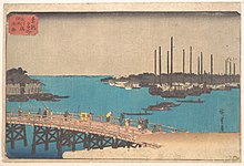
Eitai Bridge and Tsukuda Island 1835 print by Hiroshige. Tsukishima was created behind the island
Monja Street, known as the "Home of Monjayaki".

Tsukishima (月島) is a place located in Chūō, Tokyo, Japan. It is a reclaimed land next to Tsukuda district. The land reclamation completed in 1892, using earth from the dredging work performed to create a shipping channel in Tokyo Bay. At this time, it was designated as industrial area in accordance with the Fukoku Kyōhei National Policy.

Originally, Tsukuda Island was a tiny island at the river mouth. It was inhabited by a Fishing Community who migrated from Osaka in early 1600s.

It has been said that the name (literally "moon island") was originally written using the characters 築島 which can also be read "Tsukishima" but mean "constructed island".

It is currently known for its large number of restaurants serving the local speciality, monjayaki.

Tsukishima station is served by the Tokyo Metro Yurakucho Line and the Toei Subway Oedo Line.

Upper portion of Tsukishima (island neighborhood). The Sumida River crosses in the foreground; the bridge on the bottom left is the Tsukuda Bridge (Tsukuda Ohashi), above that is the white Chuo Bridge (Chuo Ohashi), and above that the blue Eitai Bridge (Eitai-bashi).

Noted people