Brynsadler
Brynsadler
| |
|---|---|
 A4222 through Brynsadler | |
Location within Rhondda Cynon Taf | |
| OS grid reference | ST030807 |
| Principal area | |
| Preserved county | |
| Country | Wales |
| Sovereign state | United Kingdom |
| Post town | PONTYCLUN |
| Postcode district | CF72 |
| Dialling code | 01443 |
| Police | South Wales |
| Fire | South Wales |
| Ambulance | Welsh |
| UK Parliament | |
| Senedd Cymru – Welsh Parliament | |
Brynsadler is a small village situated in Rhondda Cynon Taf, Wales, it is part of the community of Pontyclun.[1]
Amenities
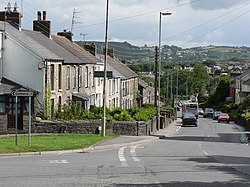
The A4222 main road to Cowbridge runs through the village; locally it is known tautologically as 'Brynsadler hill'.[2] Brynsadler used to be home to the Crown Buckley brewery housed opposite the village pub, the Ivor Arms. The brewery was bought by S A Brain and eventually relocated to Cardiff. The brewery and brewery houses were demolished and a housing estate called "Clos Brenin" replaced it.
Brynsadler also housed a chapel, called Capel Zion, located opposite the post office. It closed down and was converted into housing accommodation.
Given its position between Llanharry and Pontyclun, Brynsadler is a pit stop for many summer activities such as fun runs.
Notes
- ^ Davies, John; Jenkins, Nigel; Menna, Baines; Lynch, Peredur I., eds. (2008). The Welsh Academy Encyclopaedia of Wales. Cardiff: University of Wales Press. p. 691. ISBN 978-0-7083-1953-6.
- ^ Bryn signifies "hill".


