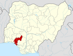
Ose, Nigeria
Appearance
Ose, Nigeria | |
|---|---|
| Country | |
| State | Ondo State ng |
| Area | |
| • Total | 566 sq mi (1,465 km2) |
| Population (2006) | |
| • Total | 144,901 |
| Time zone | UTC+1 (WAT) |
Ose is a Local Government Area in Ondo State, Nigeria. Its headquarters are in the town of Ifon. It is made up of:Ikaro, Okeluse, Ijagba, Imoru, Arimogija, Elegbeka, Ogberuwen, Ute, Ifon, Omi-alafa, Ugbonla, Ogbese Falodun in the South and: Ido-ani, Idogun, Afo, Imeri in the North. The major activity of this region is farming. They are in cocoa and plantain farming.
It has an area of 1,465 km² and a population of 144,901 at the 2006 census.
The postal code of the area is 341.[1]
References
- ^ "Post Offices- with map of LGA". NIPOST. Archived from the original on 2009-10-07. Retrieved 2009-10-20.

