Naomi, Pennsylvania
Appearance
This article needs additional citations for verification. (January 2013) |
Naomi, Pennsylvania | |
|---|---|
| Coordinates: 40°6′38″N 79°50′36″W / 40.11056°N 79.84333°W | |
| Country | United States |
| State | Pennsylvania |
| County | Fayette |
| Township | Washington |
| Area | |
| • Total | 0.29 sq mi (0.75 km2) |
| • Land | 0.22 sq mi (0.57 km2) |
| • Water | 0.07 sq mi (0.17 km2) |
| Elevation | 780 ft (240 m) |
| Population (2010) | |
| • Total | 69 |
| • Density | 311/sq mi (120.2/km2) |
| Time zone | UTC-5 (Eastern (EST)) |
| • Summer (DST) | UTC-4 (EDT) |
| FIPS code | 42-52632 |
| GNIS feature ID | 1182160 |
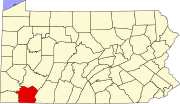
Naomi is an unincorporated community and census-designated place (CDP) in Washington Township, Fayette County, Pennsylvania, United States. As of the 2010 census the population was 69.[1]
It is located in far northwestern Fayette County and is bordered by Fairhope to the east, Fayette City to the south, and Lynnwood to the north. The western border is the Monongahela River, which forms the Washington County line. Pennsylvania Routes 201 and 906 intersect in Naomi.
References
- ^ "Geographic Identifiers: 2010 Census Summary File 1 (G001), Naomi CDP, Pennsylvania". American FactFinder. U.S. Census Bureau. Archived from the original on February 13, 2020. Retrieved July 26, 2016.


