
Svetvinčenat
Svetvinčenat | |
|---|---|
Municipality | |
| Svetvinčenat Municipality | |
 | |
 Flag | |
 Svetvinčenat Location of Svetvinčenat in Croatia | |
| Coordinates: 45°05′N 13°53′E / 45.083°N 13.883°E | |
| Country | Croatia |
| County | Istria |
| Population (2011)[1] | |
| • Total | 2,202 |
| Time zone | UTC+1 (CET) |
| • Summer (DST) | UTC+2 (CEST) |
| Website | www |
Svetvinčenat (Italian: Sanvincenti, Chakavian: Savičenta, or Savicjenta) is a village and municipality in the south of the central part of Istria, Croatia, about 16 km north of Vodnjan; elevation 250 m.
Description
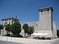
Svetvinčenat was first mentioned ca. 965 C.E., when the town began to grow around a Benedictine abbey. The town is dominated by Grimani Castle which has two round towers and a living quarters. The castle's current form dates from 1589 when the Venetian Marino Grimani renovated and bought it. The town also has a number of churches, the oldest dating form the 13th century.
Villages
The municipality has 22 villages:
Gallery
-
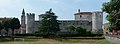 Grimani castle
 -
 Grimani castle
 -
 Castle entrance
 -
 Inside the castle
 -
 Church of Saint Vincent


References
This article needs additional citations for verification. (August 2013) |
- ^ "Population by Age and Sex, by Settlements, 2011 Census: Svetvinčenat". Census of Population, Households and Dwellings 2011. Zagreb: Croatian Bureau of Statistics. December 2012.
External links
Wikimedia Commons has media related to Svetvinčenat.
- Svetvinčenat homepage (in Croatian)
- Overall tourist offer of Svetvinčenat
Subdivisions of Istria County | ||
|---|---|---|
| Cities and towns |  | |
| Municipalities | ||
| International | |
|---|---|
| National | |
This Istria County geography article is a stub. You can help Wikipedia by expanding it. |