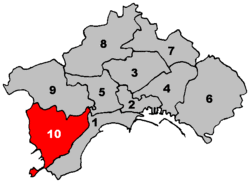
10th municipality of Naples
Appearance
Tenth Municipality of Naples
Municipalità 10 Decima Municipalità | |
|---|---|
Borough | |
 Location within Naples | |
| Country | |
| Municipality | |
| Established | 2005 |
| Seat | Via Acate, 65 |
| Government | |
| • President | Diego Civitillo |
| Area | |
• Total | 14.16 km2 (5.47 sq mi) |
| Population (2007) | |
• Total | 101,192 |
| • Density | 7,100/km2 (19,000/sq mi) |
| Website | M10 on Naples site |
The Tenth Municipality (In Italian: Decima Municipalità or Municipalità 10) is one of the ten boroughs in which the Italian city of Naples is divided.[1]
Geography
The municipality, part of the area of Campi Flegrei, is located in the western suburb of the city and borders with Pozzuoli.
Its territory includes the zones of Agnano, Nisida, Coroglio and Astroni.
Administrative division
The Tenth Municipality is divided into 2 quarters:
| Quarter | Population | Area (km²) |
|---|---|---|
| Bagnoli | 24,671
|
7.96
|
| Fuorigrotta | 76,521
|
6.20
|
| Total | 101,192
|
14.16
|
References
- ^ (in Italian) Statute of Neapolitan Municipalities
External links
- (in Italian) Municipalità 10 page on Naples website
