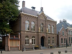
Obdam
Appearance
Obdam | |
|---|---|
 Former town hall | |
 | |
| Coordinates: 52°40′28″N 4°54′14″E / 52.67444°N 4.90389°E | |
| Country | Kingdom of the Netherlands |
| Constituent country | |
| Province | North Holland |
| Municipality | Koggenland |
| Area | |
| • Total | 20.95 km2 (8.09 sq mi) |
| • Land | 20.64 km2 (7.97 sq mi) |
| • Water | 0.31 km2 (0.12 sq mi) |
| Population (2005) | |
| • Total | 6,800 |
| • Density | 329/km2 (850/sq mi) |
| Time zone | UTC+1 (CET) |
| • Summer (DST) | UTC+2 (CEST) |
| Website | www |
Obdam () is a former municipality and a town in the Netherlands, in the province of North Holland and the region of West-Frisia. The municipality ceased to exist on 1 January 2007 when it merged with Wester-Koggenland to form the new municipality of Koggenland.
Population centres
The area of the former municipality of Obdam consists of the following cities, towns, villages and/or districts: Berkmeer, Hensbroek, Obdam, Wogmeer (partly).
Train services
These services currently (2014), depart for Hoorn, from platform 1, at xx.00 and xx.30 minutes past the hour. Travel time to Amsterdam is just 55 minutes.
Chronology
- 1503 - The van Duvenvoorde family becomes the Lordship of the town.
- 1610 - Birth of Jacob, Baron van Wassenaer, Lord of Obdam; Son of Jacob van Duvenvoorde van Wassenaer
- 1620 - Jacob van Duvenvoorde starts using the van Wassenaer family name and becomes Jacob van Duvenvoorde van Wassenaer
- 1665 - Jacob, Baron van Wassenaer, Lord Of Obdam dies during a seabattle with the English while being the captain of a Dutch vessel.
- 1979 - Founding of the new municipality, including the towns of Hensbroek and Wogmeer.
- 2007 - The Obdam municipal merges into municipal Koggenland
-
Jacob, Baron van Wassenaer, Lord of Obdam by Abraham Evertsz. van Westerveld
Local government
Before the merger, the last municipal council of Obdam consisted of 13 seats, which were divided as follows:
References
Wikimedia Commons has media related to Obdam.
- Statistics are taken from the SDU Staatscourant


