Mount Kulal
Appearance
| Mount Kulal | |
|---|---|
| Highest point | |
| Elevation | 2,285 m (7,497 ft)[1] |
| Prominence | 1,542 m (5,059 ft)[1] |
| Listing | Ultra |
| Coordinates | 02°43′45″N 36°55′24″E / 2.72917°N 36.92333°E[1] |
| Geography | |
| Location | Kenya |
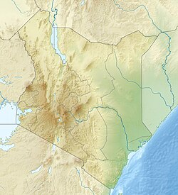
Mount Kulal is an eroded-down extinct volcano located in northern Kenya, just east of Lake Turkana. The mountain has an elevation of 2,285 metres (7,497 ft). The lakeside town of Loiyangalani is located 50 kilometres (31 mi) west of Mount Kulal.
Mount Kulal has been a biosphere reserve since 1978.[2]
Mount Kulal is the only place where Kulal white-eye (Zosterops kulalensis) has been found.[3]
See also
References
- ^ a b c "Africa Ultra-Prominences". Peaklist.org. 2011-12-03. Retrieved 2016-11-02.
- ^ "MAB Biosphere Reserves Directory". UNESCO.org. Retrieved 2016-11-02.
- ^ "Mount Kulal (Endemic Bird Areas of the world)". Birdlife.org. Retrieved 2016-11-02.
External links
- "Kulal Mountain of Northern Kenya". Kilimanjaro.cc. 2014-02-09. Retrieved 2016-11-02.
- "Mount Kulal". Peakbagger.com. 2004-11-01. Retrieved 2016-11-02.

