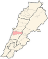
Bsous
Bsous
بسوس | |
|---|---|
| Coordinates: 33°49′N 35°35′E / 33.817°N 35.583°E | |
| Country | |
| Governorate | Mount Lebanon Governorate |
| District | Aley District |
| Time zone | UTC+2 (EET) |
| • Summer (DST) | +3 |
Bsous (Arabic: بسوس), is a village in the Aley District of Mount Lebanon[1] with an estimated population of 6,000. It is located 360 meters above sea level and 14 kilometres from the capital, Beirut.[1] It is both a summer resort as well as being inhabited during the winter months. This is due to its proximity to Beirut. The name "Bsous" derives from the Phoenician.
Etymology
The name "Bsous" derives from the Phoenician "Bet Sus" and means the place of horses.
Agriculture
Prickly pear, apricot, grape, blackberry, olive. [citation needed]
Religion
The Maronite Catholic parish of Our Lady of Bsous is part of the Beirut diocese and has two churches: [citation needed]
- Notre Dame de Bsous
- St. Antoine de Padova
The Greek Orthodox parish of Bsous is part of the Mount Lebanon diocese and has one church:
- Notre Dame de Saidnaya
Geography
Bsous is bordered by Aley, Kahale, Ain El Remaneh, Bdadoun, Wadi Chahrour, and Qmatiyeh. It is 200 to 730 meters above sea level and 15 km from Beirut. Bsous area is 2,457,139.61 m² (sq meters)
Arts and entertainment
Notable people
- Dr.Habib Abou Sakr - ex-Director General - Ministry of Finance - Lebanon
References
Bsous website : http://www.bsous.com/33°49′N 35°35′E / 33.817°N 35.583°E
Bsous website : http://www.bsous.com/


