
Dargo, Victoria
| Dargo Victoria | |
|---|---|
.jpg) Prospector's hut Upper Dargo, 1870 | |
 Dargo | |
| Coordinates | 37°29′S 147°16′E / 37.483°S 147.267°E |
| Population | 144 (2006 census)[1] |
| Postcode(s) | 3862 |
| Elevation | 203 m (666 ft) |
| Location |
|
| LGA(s) | Shire of Wellington |
| State electorate(s) | Gippsland East |
| Federal division(s) | Gippsland |
Dargo is a town in Victoria, Australia, located 348 kilometres (216 mi) east of Melbourne, in the Shire of Wellington. At the 2016 census, Dargo and the surrounding area had a population of 99.[1] The median age of residents was 63.
The town provided a stopover for Victorian Gold Rush miners on their way to the goldfields of Grant, Talbotville, and Crooked River. The Post Office opened on 18 March 1868.[2]
Today the town is a producer of timber and beef cattle, and outside these industries tourism has become a major source of revenue. The town is a popular destination for four-wheel drive enthusiasts, bushwalkers, sambar deer hunters, and trout fishermen. An annual Walnut Festival formerly ran through the Australian Easter holiday period and was usually well attended.
-
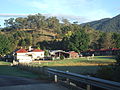 The Dargo Hotel, a major social gathering point for the district.
 -
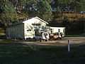
 The Dargo Store, an important refuel and resupply point.
 -
 The Dargo Community Hall.


References
- ^ a b Australian Bureau of Statistics (27 June 2017). "2016 Community Profiles: Dargo". 2016 Census of Population and Housing. Retrieved 19 March 2019.
- ^ Premier Postal History, Post Office List, retrieved 11 April 2008
External links
This article about a location in Gippsland (region) is a stub. You can help Wikipedia by expanding it. |