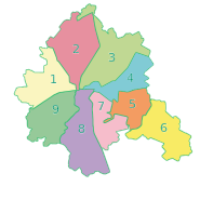
Shevchenkivskyi District, Kharkiv
Appearance
Shevchenkivskyi District
Шевченківський район | |
|---|---|
 | |
| Country | |
| Oblast | Kharkiv Oblast |
| Area | |
• Total | 62 km2 (24 sq mi) |
| Population | |
• Total | 231,641 |
| Time zone | UTC+2 (EET) |
| • Summer (DST) | UTC+3 (EEST) |

|
Shevchenkivskyi District (Template:Lang-uk) is urban district of the city of Kharkiv, Ukraine, named after the Ukrainian poet Taras Shevchenko.[1]
The district was created in 1932 out of parts of Ivano-Lysohirskyi and Petynsko-Zhuravlivskyi districts. It was named as Dzerzhynskyi after the head of Cheka (All-Russian Extraordinary Commission). It was renamed to its current name in February 2016 to comply with decommunization laws.[1]
Places
- Universytetska hirka
- Derzhprom (Gosprom)
- Pavlivka
- Shatylivka
- Sokolnyky
- Pavlove Pole
- Oleksiivka
- Tykhi vulytsi
References
- ^ a b (in Ukrainian) Another 48 streets and 5 districts "decommunized" in Kharkiv, Ukrayinska Pravda (3 February 2015)
(in Russian) Three districts renamed in Kharkiv, SQ (3 February 2015)
(in Ukrainian) It was decided not to rename the Zhovtnevyi and the Frunzenskyi districts in Kharkiv, Korrespondent.net (3 February 2015)
External links
- Dzerzhynsky Raion website
- Volkov, E. Dzerzhynskiy Raion: From its origins to the contemporary times (ДЗЕРЖИНСКИЙ РАЙОН: ОТ ИСТОКОВ ДО СОВРЕМЕННОСТИ). Eduard Volkov website. 20 May 2010.
50°01′N 36°13′E / 50.017°N 36.217°E
