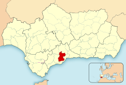
Valle del Guadalhorce
Appearance
Valle del Guadalhorce | |
|---|---|
 Location in the province of Málaga. | |
| Country | |
| Autonomous community | Andalusia |
| Province | Málaga |
| Capital | Coín |
| Area | |
| • Total | 805.6 km2 (311.0 sq mi) |
| Population (2018)[1] | |
| • Total | 139,915 |
| • Density | 170/km2 (450/sq mi) |
| Time zone | UTC+1 (CET) |
| • Summer (DST) | UTC+2 (CEST) |
The Valle del Guadalhorce is a comarca in the province of Málaga, Andalusia, southern Spain. It includes 8 municipalities and is part of the natural region of the Guadalhorce river.
Coín is traditionally considered the most important town in the comarca.
Municipalities
| Municipality | Area (km²) |
Population 2011[2] |
Population 2018[3] |
|---|---|---|---|
| Alhaurín de la Torre | 82.7 | 37,020 | 39,911 |
| Alhaurín el Grande | 73.1 | 23,164 | 24,123 |
| Almogía | 162.9 | 4,081 | 3,770 |
| Álora | 169.6 | 13,273 | 12,951 |
| Cártama | 105.1 | 23,225 | 25,758 |
| Coín | 127.4 | 21,692 | 21,716 |
| Pizarra | 63.6 | 9,099 | 9,118 |
| Valle de Abdalajís | 21.2 | 2,742 | 2,568 |
| Totals | 805.6 | 134,296 | 139,915 |
References
External links
- Rural group of Valle del Guadalhorce (in Spanish)
