
Rule Water
The Rule Water is a river in the Scottish Borders area of Scotland, and a tributary of the River Teviot. The Rule Water rises in Wauchope Forest and passes Hobkirk, Bonchester Bridge, Hallrule, Abbotrule, and Bedrule until it joins the River Teviot at Spittal-on-Rule.
Other placenames include the name of the Rule Water, e.g. Ruletownhead.
History
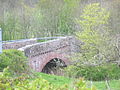
In the 19th century a toll road was constructed from Carter Bar to the market town on Hawick necessitating the building of the Bonchester Bridge over Rule Water.[1]
A history of the Rule Water entitled "Rulewater and its People; An account of the Valley of the Rule and its Inhabitants" by George Tancred was published in 1907.[2]
See also
References
- ^ Redpath, Alastair M. (2014-05-15). Hawick Through Time. Amberley Publishing Limited. ISBN 978-1-4456-3926-0.
- ^ George Tancred (1907). Rulewater and Its People: An Account of the Valley of the Rule and Its ... New York Public Library. Printed at theUniversity Press by T. and A. Constable.
Gallery
-
 Rule Water, Bonchester Bridge
 -
 Rule Water at Hallrule
 -
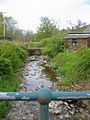
 Rule Water at Hobkirk church
 -
 Rule Water at Hartshaugh


External links
- Gazetteer for Scotland: Rule Water
- RCAHMS record of Rule Water
- RCAHMS/Canmore record of Spital-on-Rule Bridge
55°29′N 2°39′W / 55.483°N 2.650°W
This Scottish Borders location article is a stub. You can help Wikipedia by expanding it. |