Augignac
- 閩南語 / Bân-lâm-gú
- Català
- Cebuano
- Deutsch
- Español
- Euskara
- فارسی
- Français
- Italiano
- Қазақша
- Kurdî
- Latina
- Magyar
- Malagasy
- Bahasa Melayu
- Nederlands
- Нохчийн
- Occitan
- Oʻzbekcha / ўзбекча
- Piemontèis
- Polski
- Português
- Română
- Русский
- Shqip
- Slovenčina
- Српски / srpski
- Srpskohrvatski / српскохрватски
- Svenska
- Татарча / tatarça
- Basa Ugi
- Українська
- Vèneto
- Tiếng Việt
- Winaray
- 粵語
- 中文
Tools
Actions
General
Print/export
Print/export
In other projects
From Wikipedia, the free encyclopedia
This is an old revision of this page, as edited by Markussep (talk | contribs) at 11:17, 16 May 2020 (→External links: rm dead external map link, removed: lion1906). The present address (URL) is a permanent link to this revision, which may differ significantly from the current revision.
Revision as of 11:17, 16 May 2020 by Markussep (talk | contribs) (→External links: rm dead external map link, removed: lion1906)
Commune in Nouvelle-Aquitaine, France
Augignac | |
|---|---|
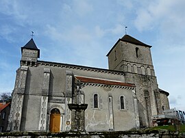
 The church in Augignac | |
| Coordinates: 45°42′06″N 0°35′31″E / 45.7016°N 0.592°E / 45.7016; 0.592 | |
| Country | France |
| Region | Nouvelle-Aquitaine |
| Department | Dordogne |
| Arrondissement | Nontron |
| Canton | Périgord Vert Nontronnais |
| Intercommunality | Périgord Nontronnais |
| Government | |
| • Mayor (2014-2020) | Pierre Peyrazat |
| Area 1 | 22.64 km2 (8.74 sq mi) |
| Population (2021)[1] | 822 |
| • Density | 36/km2 (94/sq mi) |
| Time zone | UTC+01:00 (CET) |
| • Summer (DST) | UTC+02:00 (CEST) |
| INSEE/Postal code | 24016 /24300 |
| Elevation | 189–306 m (620–1,004 ft) |
| 1 French Land Register data, which excludes lakes, ponds, glaciers > 1 km2 (0.386 sq mi or 247 acres) and river estuaries. | |
Augignac is a commune in the Dordogne department in Nouvelle-Aquitaine in southwestern France.
Augignac is located between Nontron and Piégut-Pluviers in the heart of the Parc Naturel Régional de Périgord-Limousin
Population
| Year | Pop. | ±% |
|---|---|---|
| 1962 | 798 | — |
| 1968 | 876 | +9.8% |
| 1975 | 791 | −9.7% |
| 1982 | 818 | +3.4% |
| 1990 | 838 | +2.4% |
| 1999 | 791 | −5.6% |
| 2008 | 826 | +4.4% |
| 2015 | 815 | −1.3% |
See also
References
- ^ "Populations légales 2021". The National Institute of Statistics and Economic Studies. 28 December 2023.
External links
Wikimedia Commons has media related to Augignac.
| International | |
|---|---|
| National | |
| Other | |
This Dordogne geographical article is a stub. You can help Wikipedia by expanding it. |
Retrieved from "https://en.wikipedia.org/w/index.php?title=Augignac&oldid=956982190"
Hidden categories:
- Articles with short description
- Short description is different from Wikidata
- Coordinates on Wikidata
- Pages using infobox settlement with image map1 but not image map
- Commons category link is on Wikidata
- Articles with VIAF identifiers
- Articles with BNF identifiers
- Articles with BNFdata identifiers
- Articles with SUDOC identifiers
- All stub articles
- Pages using the Kartographer extension


