Teteriv
Appearance
| Teteriv, Тетерiв | |
|---|---|
 Teteriv River near Zhytomyr | |
 | |
| Location | |
| Country | Ukraine |
| Physical characteristics | |
| Source | |
| • location | Zhytomyr Oblast |
| Mouth | Dnieper |
• location | Kiev Reservoir |
• coordinates | 51°01′57″N 30°17′03″E / 51.03250°N 30.28417°E |
| Length | 385 km (239 mi) |
| Basin size | 15,300 km2 (5,900 sq mi) |
| Discharge | |
| • average | 18,4 m³/s[1] |
| Basin features | |
| Progression | Dnieper→ Dnieper–Bug estuary→ Black Sea |
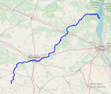
The Teteriv (Ukrainian: Тетерiв) is a right tributary of the Dnieper River in Ukraine. It has a length of 365 km and a drainage basin of 15,300 km².[2][3][1][4]
In the underflow the valley of the Teteriv in Polissia on up to 4 km, the width of the river widens up to 40-90 meter, before it flows into the Dnieper.[4]
The Teteriv is replenished predominantly by snow and rain. It usually freezes over from December to March.
Large cities located on the river are: Zhytomyr, the administrative center of the Zhytomyr Oblast, Korostyshiv, and Radomyshl.[4]
Tributaries
The important tributaries of the river are
- Left: Syvka, Ibr, Budychyna, Oleshka, Lisova, Perebehla, Hodynka, Shyika, Bobrivka, Kyzhynka, Chervonyi, Krutyi Yar, Perlivka, Pobytivka, Lisova Kamyanka, Kalynivka, Berezyna, Ruda, Levcha, Myka, Hlukhivka, Mezherichka, Myroch, Vyrva, Irsha, Ravka, Huche, Zamochek, Parnia, Kropyvnia, Zhereva, Liubsha, Bolotna, Terniava, Khocheva
- Right: Kobylykha, Teterivka, Chamyshel, Hremliaha, Tetynets, Hlybochok, Koshcha, Hnylopyat, Huiva, Rusiatynka, Dorohynka, Hnylyi Potik, Kokhanivka, Ivyanka, Krychanka, Velyki Lozy, Dubovets, Bilka, Kodra, Piskivka, Tal, Zdvyzh
References
- ^ a b "Тетерев" (in Russian). Большая Советская Энциклопедия. Retrieved 2019-04-23.
- ^ Izsák Tibor (2007). Ukrajna természeti földrajza (pdf) (in Hungarian). II. Rákóczi Ferenc Kárpátaljai Magyar Főiskola. p. 95. Retrieved 2019-04-23.
- ^ "NÉVJEGYZÉK-SZÓTÁR az UKRAJNA TERMÉSZETI FÖLDRAJZA tantárgyhoz" (pdf) (in Hungarian). II. Rákóczi Ferenc Kárpátaljai Magyar Főiskola. Retrieved 2019-04-23.
- ^ a b c "Teteriv River". Encyclopedia of Ukraine. Retrieved 2019-04-23.
Wikimedia Commons has media related to Teteriv (river).

