
Shirokanedai Station
N02 I02 Shirokanedai Station 白金台駅 | |||||||||||||||||||||
|---|---|---|---|---|---|---|---|---|---|---|---|---|---|---|---|---|---|---|---|---|---|
 Exit No. 2 in March 2017 | |||||||||||||||||||||
| General information | |||||||||||||||||||||
| Location | 4-5-10 Shirokanedai, Minato-ku, Tokyo Japan | ||||||||||||||||||||
| Operated by |
| ||||||||||||||||||||
| Line(s) | |||||||||||||||||||||
| Distance | 1.3 km from Meguro | ||||||||||||||||||||
| Platforms | 2 side platforms | ||||||||||||||||||||
| Tracks | 2 | ||||||||||||||||||||
| Other information | |||||||||||||||||||||
| Station code | N-02, I-02 | ||||||||||||||||||||
| History | |||||||||||||||||||||
| Opened | 26 September 2000 | ||||||||||||||||||||
| Services | |||||||||||||||||||||
| |||||||||||||||||||||
| |||||||||||||||||||||

Shirokanedai Station (白金台駅, Shirokanedai-eki) is a subway station in Minato, Tokyo, operated jointly by the Tokyo subway operators Tokyo Metro and Tokyo Metropolitan Bureau of Transportation (Toei).
Lines
Shirokanedai Station is served by the Tokyo Metro Namboku Line (station number N-02) and the Toei Mita Line (station number I-02), and lies 1.3 km (0.81 mi) from the starting point of both lines at Meguro Station.[1] It is the least used station on the Toei network, with 5,070 boardings per day in 2018.[2]
Station layout
The station has two underground side platforms on the fourth basement ("B4F") level, serving two tracks shared by both Tokyo Metro Namboku Line and the Toei Mita Line services.
Platforms
| 1 | N Tokyo Metro Namboku Line | for Akabane-iwabuchi SR Saitama Rapid Railway Line for Urawa-Misono |
| I Toei Mita Line | for Nishi-Takashimadaira | |
| 2 | N Tokyo Metro Namboku Line | for Meguro MG Tokyu Meguro Line for Hiyoshi |
| I Toei Mita Line | for Meguro MG Tokyu Meguro Line for Hiyoshi |
-
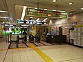 The ticket barriers in March 2016
 -
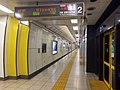 Platform 2 in October 2014


History
The station opened on 26 September 2000.[1]
Surrounding area
- Meiji Gakuin University Shirokane Campus
- Meiji Gakuin Senior High School
- Institute of Medical Science
- The Institute for Nature Study
- Matsuoka Museum
See also
References
- ^ a b Terada, Hirokazu (19 January 2013). データブック日本の私鉄 [Databook: Japan's Private Railways] (in Japanese). Japan: Neko Publishing. p. 216. ISBN 978-4-7770-1336-4.
- ^ "Outline of Toei Transportationpublisher=Toei Subway" (PDF). Retrieved 22 Feb 2020.
External links
Wikimedia Commons has media related to Shirokanedai Station.
- Tokyo Metro station information (in Japanese)
- Toei station information (in Japanese)