
Cătina, Cluj
Cătina
Katona | |
|---|---|
 Cătina Orthodox Church | |
 Location in Cluj County | |
 Cătina Location in Romania | |
| Coordinates: 46°50′40″N 24°09′50″E / 46.84444°N 24.16389°E | |
| Country | Romania |
| County | Cluj |
| Established | 1327 |
| Subdivisions | Cătina, Copru, Feldioara, Hagău, Hodaie, Valea Caldă |
| Government | |
| • Mayor | Alexandru Bota |
| Area | 52.77 km2 (20.37 sq mi) |
| Population (2021-12-01)[1] | 1,567 |
| • Density | 30/km2 (77/sq mi) |
| Time zone | EET/EEST (UTC+2/+3) |
| Area code | +40 x64 |
| Vehicle reg. | CJ |
| Website | www |
Cătina (Template:Lang-hu; Template:Lang-de) is a commune in Cluj County, Transylvania, Romania. It is composed of six villages: Cătina, Copru (Kapor), Feldioara (Melegföldvár), Hagău (Hágótanya), Hodaie and Valea Caldă (Melegvölgyitanya).
Demographics
According to the 2002 census, Romanians made up 75.71% of the population, Hungarians made up 20.83% and Roma made up 3.40%.[2]
Images
-
 Cătina lakes
 -
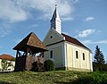 Roman Catholic church

.JPG)
References
- ^ "Populaţia rezidentă după grupa de vârstă, pe județe și municipii, orașe, comune, la 1 decembrie 2021" (XLS). National Institute of Statistics.
- ^ "Archived copy". Archived from the original on 2012-04-26. Retrieved 2011-08-17.
{{cite web}}: CS1 maint: archived copy as title (link)

This Cluj County location article is a stub. You can help Wikipedia by expanding it. |