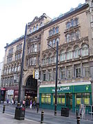
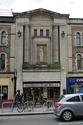
St Mary Street/High Street
Appearance
St Mary Street (Heol Eglwys Fair) and High Street (Heol Fawr) are major commercial streets in the Castle Quarter of Cardiff city centre, Wales, which form a major thoroughfare running south from the gatehouse of Cardiff Castle. High Street begins at the junction of Castle Street on the A4161 and ends at the junction of Church Street and Quay Street, from where St Mary Street begins until the roundabout at Callaghan Square on the A4160.

Notable buildings past and present
Present buildings
- House of Fraser, formerly Howells department store
- Cardiff Market
- Hodge House
- Prince of Wales Theatre (now a pub)
- High Street Arcade
- Morgan Arcade
- Royal Arcade
Demolished buildings
- Cardiff Town Hall[1]
- Cardiff Gaol, site of Cardiff Market
- The first Cardiff Free Library, above the St. Mary Street entrance to the Royal Arcade
- YMCA building
| Buildings past and present |
|---|
Notes
- ^ "The Town Hall, St. Mary Street, Cardiff, late 19th century". Culturenet Cymru. Retrieved 11 February 2009.
External links
 Media related to St Mary Street, Cardiff at Wikimedia Commons
- Official website of 'Changing landscapes: Improving St Mary Street and High Street'


