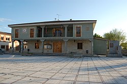
Santa Croya de Tera
Appearance
From Wikipedia, the free encyclopedia
This is an old revision of this page, as edited by MateoSag (talk | contribs) at 08:17, 4 June 2020 (images and flags). The present address (URL) is a permanent link to this revision, which may differ significantly from the current revision.
This article does not cite any sources. Please help improve this article by adding citations to reliable sources. Unsourced material may be challenged and removed. Find sources: "Santa Croya de Tera" – news · newspapers · books · scholar · JSTOR (December 2012) (Learn how and when to remove this message) |
Place in Castile and León, Spain
Santa Croya de Tera | |
|---|---|
 | |
 | |
| Country | |
| Autonomous community | |
| Province | |
| Municipality | Santa Croya de Tera |
| Area | |
| • Total | 21 km2 (8 sq mi) |
| Population (2018)[1] | |
| • Total | 307 |
| • Density | 15/km2 (38/sq mi) |
| Time zone | UTC+1 (CET) |
| • Summer (DST) | UTC+2 (CEST) |
| Website | Official website |
Santa Croya de Tera is a municipality located in the province of Zamora, Castile and León, Spain. According to the 2004 census (INE), the municipality has a population of 422 inhabitants.
41°59′N 5°58′W / 41.983°N 5.967°W / 41.983; -5.967
This article about a location in the province of Zamora, Spain is a stub. You can help Wikipedia by expanding it. |
- ^ Municipal Register of Spain 2018. National Statistics Institute.
Hidden categories:
- Pages using gadget WikiMiniAtlas
- Articles lacking sources from December 2012
- All articles lacking sources
- Articles with short description
- Short description is different from Wikidata
- Official website different in Wikidata and Wikipedia
- Pages using infobox settlement with no map
- Pages using infobox settlement with no coordinates
- Coordinates on Wikidata
- All stub articles
- Pages using the Kartographer extension

