Ariniș
Appearance
Ariniș | |
|---|---|
 Reformed Church in Ariniș | |
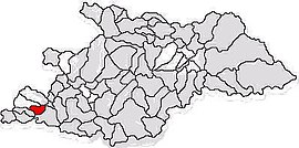
 Location in Maramureș County | |
| Coordinates: 47°30′03″N 23°13′49″E / 47.50083°N 23.23028°E | |
| Country | Romania |
| County | Maramureș |
| Government | |
| • Mayor | Gheorghe Mureșan (PSD) |
| Area | 27.13 km2 (10.47 sq mi) |
| Population (2021-12-01)[1] | 1,081 |
| • Density | 40/km2 (100/sq mi) |
| Time zone | EET/EEST (UTC+2/+3) |
| Vehicle reg. | MM |
| Website | comunaarinis |

Ariniș (Hungarian: Égerhát) is a commune in Maramureș County, Crișana, Romania. It is composed of three villages: Ariniș, Rodina (Rogyina) and Tămășești (Szilágyegerbegy).
History
The village of Ariniș is documentary certified since 1543 under the name of "Egherhat". But Ariniș is archaeologically documented in the Middle Ages, named "Sub ogrăzi”,Bronze Age, culture Suciu de Sus
Economy
The main economic activity in the commune is agriculture, which takes place in 582 family farms on an area of 2246 ha of agricultural land. Inside the village there is a fish farm.
The industrial part is represented by a manufacturer of rubber products.
Residents are working at several stores and warehouses of materials, too.
Sights
- Orthodox Church in Ariniș, built in the 20th century


