Săcel, Maramureș
Appearance
This article needs additional citations for verification. (March 2020) |
Săcel | |
|---|---|
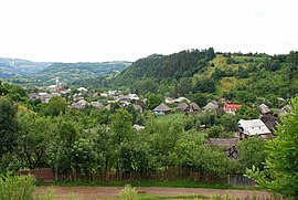
 View of the village | |
 Location in Maramureș County | |
| Coordinates: 47°38′N 24°26′E / 47.633°N 24.433°E | |
| Country | Romania |
| County | Maramureș |
| Area | 79.89 km2 (30.85 sq mi) |
| Elevation | 400 m (1,300 ft) |
| Population (2021-12-01)[1] | 3,142 |
| • Density | 39/km2 (100/sq mi) |
| Time zone | EET/EEST (UTC+2/+3) |
| Vehicle reg. | MM |
Săcel (Hungarian: Izaszacsal, Yiddish: סיטשל) is a commune in Maramureș County, Maramureș, Romania. Composed of a single village, Săcel, it is the last locality up the Iza Valley. From here one can get to the Vișeu Valley through Dealul Moiseiului Pass (towards the northeast) and to Transylvania (specifically Năsăud, towards the south) through Dealul Ștefāniței Pass, which separates the Țibleș and Rodna Mountains.
Săcel pottery
Săcel is famous for its red, unglazed pottery obtained through ancient, Dacian techniques that date back more than 2000 years ago. Nowadays, an ancient Roman type oven is used for burning the clay. Săcel pots are manufactured in Dacian style and they are ornamented using mineral elements.
References
External links
 Media related to Săcel, Maramureș at Wikimedia Commons


