Cohagen, Montana
Appearance
Cohagen, Montana | |
|---|---|
 Cohagen Bar in Cohagen, Montana | |
| Coordinates: 47°3′16″N 106°37′3″W / 47.05444°N 106.61750°W | |
| Country | United States |
| State | Montana |
| County | Garfield |
| Elevation | 2,720 ft (830 m) |
| Time zone | UTC-7 (Mountain (MST)) |
| • Summer (DST) | UTC-6 (MDT) |
| ZIP codes | 59322 |
| GNIS feature ID | 806931 |
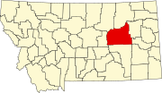
Cohagen is an unincorporated community in southeastern Garfield County, Montana, United States. It lies along Highway 59 southeast of the town of Jordan, the county seat of Garfield County.[1] Its elevation is 2,720 feet (829 m).[2] Although Cohagen is unincorporated, it has a post office, with the ZIP code of 59322,[3] which opened on 1905-08-18.[4]
Climate
According to the Köppen Climate Classification system, Cohagen has a semi-arid climate, abbreviated "BSk" on climate maps.[5]
References
- ^ Rand McNally. The Road Atlas '08. Chicago: Rand McNally, 2008, p. 61.
- ^ U.S. Geological Survey Geographic Names Information System: Cohagen, Montana
- ^ Zip Code Lookup Archived 2011-06-15 at the Wayback Machine
- ^ U.S. Geological Survey Geographic Names Information System: Cohagen Post Office
- ^ Climate Summary for Cohagen, Montana


