Nuth
Nuth
Nut | |
|---|---|
Former Municipality | |
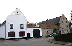
 Old farmhouse in Arensgenhout | |
 Location in Limburg | |
| Coordinates: 50°55′N 5°53′E / 50.917°N 5.883°E | |
| Country | Netherlands |
| Province | Limburg |
| Municipality | Beekdaelen |
| Government | |
| • Body | Municipal council |
| • Mayor | Désirée Schmalschläger (GroenLinks) |
| Area | |
| • Total | 33.13 km2 (12.79 sq mi) |
| • Land | 33.09 km2 (12.78 sq mi) |
| • Water | 0.04 km2 (0.02 sq mi) |
| Elevation | 86 m (282 ft) |
| Population (January 2021)[4] | |
| • Total | data missing |
| Demonym | Nutter |
| Time zone | UTC+1 (CET) |
| • Summer (DST) | UTC+2 (CEST) |
| Postcode | 6333, 6336, 6360–6363 |
| Area code | 045 |
| Website | www |
Nuth (Dutch pronunciation: [nɵt] ; Limburgish: Nut) is a village and was a municipality in the province of Limburg, situated in the southern Netherlands. In January 2019, the municipality merged with Schinnen and Onderbanken to form Beekdaelen.[5]
The village of Nuth has 5,452 inhabitants, and is with that the largest village of the municipality. The town hall of the municipality Nuth was also situated in the village Nuth. The other villages in the municipality were Hulsberg with 3,980 inhabitants, Schimmert with 3,226, Wijnandsrade with 1,647 and Vaesrade with 997 inhabitants (data: 1-1-2017). The other population centres belong to one of the following villages.
Population centres
Aalbeek, Arensgenhout, Grijzegrubben, Helle, Hellebroek, Hulsberg, Laar, Schimmert, Swier, Terstraten, Vaesrade, Wijnandsrade.
Topography
Dutch Topographic map of the municipality of Nuth, June 2015
Transportation
Some facts about Nuth
- The patron Saint of Nuth is St. Bavo, after which the parish is named.
- The municipality expanded all the way from Hoensbroek to Meerssen.
- From 2004 Nuth boasted a one Michelin star restaurant, In de'n Dillegaard, and Nuth made the international press when the restaurant owner returned the coveted star in 2009 over concerns of being too elitist.[6]
References
- ^ "Collegeleden" [Members of the board] (in Dutch). Gemeente Nuth. Archived from the original on 6 June 2013. Retrieved 16 November 2013.
- ^ "Kerncijfers wijken en buurten 2020" [Key figures for neighbourhoods 2020]. StatLine (in Dutch). CBS. 24 July 2020. Retrieved 19 September 2020.
- ^ "Postcodetool for 6361BZ". Actueel Hoogtebestand Nederland (in Dutch). Het Waterschapshuis. Retrieved 16 November 2013.
- ^ "Bevolkingsontwikkeling; regio per maand" [Population growth; regions per month]. CBS Statline (in Dutch). CBS. 1 January 2021. Retrieved 2 January 2022.
- ^ "Gemeenteraad Beekdaelen beëdigd in gemeentehuis Nuth" [Town council of Beekdaelen sworn in at Nuth municipality office] (in Dutch). 1Limburg. Retrieved 2 March 2019.
- ^ Dutch restaurant gives Michelin star back
External links
 Media related to Nuth at Wikimedia Commons
- Official website


