
Orava Parish
Orava Parish
Orava vald | |
|---|---|
.JPG) Parish countryside | |
 Flag  Coat of arms | |
 Orava Parish within Põlva County. | |
| Country | |
| County | |
| Administrative centre | Orava |
| Area | |
| • Total | 175.6 km2 (67.8 sq mi) |
| Population (2008) | |
| • Total | 854 |
| • Density | 4.9/km2 (13/sq mi) |
| Website | www.orava.ee |
Orava Parish (Estonian: Orava vald) was a rural municipality in south-eastern Estonia, Põlva County. The municipality had a population of 854 (as of 1 January 2008) and covered an area of 175.52 km². The population density was 4.9 inhabitants per km².
Villages
There were a total of 30 villages in Orava Parish. Administrative centre of the municipality was Orava village. Other villages were Hanikase, Jantra, Kahkva, Kakusuu, Kamnitsa, Kliima, Korgõmõisa, Kõivsaare, Kõliküla, Kõvera, Lepassaare, Liinamäe, Luuska, Madi, Marga, Oro, Piusa, Praakmani, Päka, Pääväkese, Rebasmäe, Riihora, Rõssa, Soe, Soena, Suuremetsa, Tamme, Tuderna and Vivva
Images
-
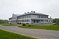 Orava school
 -
 Rebasmäe spring
 -
 Piusa caves
 -
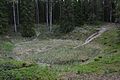 Põrguhaud, biggest of the Ilumetsa craters


External links
- Official website (in Estonian)
57°53′14″N 27°27′29″E / 57.88722°N 27.45806°E
| Rural municipalities | ||
|---|---|---|
This Põlva County location article is a stub. You can help Wikipedia by expanding it. |