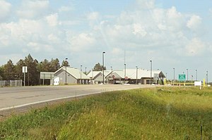
Northgate Border Crossing
Appearance
| Northgate Border Crossing | |
|---|---|
 US Border Inspection Station at Northgate, North Dakota | |
| Location | |
| Country | United States; Canada |
| Location |
|
| Coordinates | 48°59′56″N 102°16′31″W / 48.998844°N 102.275164°W |
| Details | |
| Opened | 1962 |
| US Phone | (701) 596-3805 |
| Canadian Phone | (306) 483-5111 |
| Hours | Open 9:00 AM-10:00 PM |
| Website http://www.cbp.gov/contact/ports/northgate | |
The Northgate Border Crossing connects the cities of Bowbells, North Dakota and Alameda, Saskatchewan on the Canada–US border. It is reached by North Dakota Highway 8 on the American side and Saskatchewan Highway 9 on the Canadian side. This border crossing opened in 1962, when Highway 8 was built, which passed a half mile west of the small town of Northgate, ND[1] After being idle for years, the Canadian National Railway upgraded its tracks at this crossing to support rail traffic from the Bakken oil field.[2] The US upgraded its border station on Highway 8 in 2004.

The former Port of Entry building to the left was razed in 2014/2015 for unknown reasons.
See also
References
- ^ "NORTHGATE, NORTH DAKOTA". Ghosts of North Dakota. Retrieved 6 December 2015.
- ^ North Dakota Department of Transportation; Government of Saskatchewan. "Northgate Railroad Crossing". Meeting Archives. US - Canada Transportation Border Working Group. Retrieved 11 December 2015.
