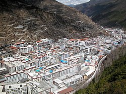
Lucheng, Kangding
Lucheng
炉城街道 · མདོ་ཁྲིན་རྡལ། | |
|---|---|
 View of Lucheng | |
| Coordinates: 30°03′19″N 101°57′53″E / 30.05528°N 101.96472°E | |
| Country | China |
| Province | Sichuan |
| Autonomous prefecture | Garzê Tibetan Autonomous Prefecture |
| County-level city | Kangding |
| Elevation | 2,560 m (8,400 ft) |
| Population (2010) | |
| • Total | 41,399 |
| • Major Nationalities | Han Tibetan |
| Time zone | UTC+8 (China Standard) |
| Postal code | 610000 |
| Website | www |
| Lucheng/Dartsedo | |||||||
|---|---|---|---|---|---|---|---|
| Chinese name | |||||||
| Simplified Chinese | 炉城 | ||||||
| Traditional Chinese | 爐城 | ||||||
| |||||||
| Alternative Chinese name | |||||||
| Simplified Chinese | 打箭炉 | ||||||
| Traditional Chinese | 打箭爐 | ||||||
| Postal | Tatsienlu | ||||||
| |||||||
| Tibetan name | |||||||
| Tibetan | མདོ་ཁྲིན། | ||||||
| |||||||
Lucheng Subdistrict, often called Kangding[citation needed], is one of two subdistricts of Kangding city in Garzê Tibetan Autonomous Prefecture in western Sichuan Province in southwest China.[1][2] Lucheng Subdistrict serves as the seat of the Kangding city government.[3] As of 2010, the subdistrict has a population of 41,399 people.[4]
Administrative Divisions
The subdistrict is divided into four neighborhood committees and ten village committees.[5]
Transport
References
- ^ "2019年统计用区划代码". www.stats.gov.cn (in Chinese). 2019. Retrieved 2020-06-16.
{{cite web}}: CS1 maint: url-status (link) - ^ "行政区划". Kangding City People's Government (in Chinese). 2019-07-05. Archived from the original on 2020-06-16. Retrieved 2020-06-16.
- ^ "康定市概况地图". xzqh.org (in Chinese). 2015-03-23. Archived from the original on 2020-06-16. Retrieved 2020-06-16.
- ^ "康定市历史沿革". xzqh.org (in Chinese). 2015-03-23. Archived from the original on 2020-06-16. Retrieved 2020-06-16.
- ^ "2019年统计用区划代码和城乡划分代码". stats.gov.cn (in Chinese). 2019. Retrieved 2020-06-16.
{{cite web}}: CS1 maint: url-status (link)
Further reading
- Dorje, Gyurme (1999). Footprint Tibet Handbook with Bhutan. 2nd Edition. Footprint Handbooks, Bath, England. ISBN 1-900949-33-4.
- Forbes, Andrew ; Henley, David (2011). China's Ancient Tea Horse Road. Chiang Mai: Cognoscenti Books. ASIN: B005DQV7Q2
- Kendall, Elizabeth (1913). A Wayfarer in China: Impressions of a trip across West China and Mongolia. The Riverside Press, Cambridge. Boston and New York.
- Leffman, David, et al. (2005). The Rough Guide to China. 4th Edition. Rough Guides, New York, London, Delhi. ISBN 978-1-84353-479-2.
External links
Wikimedia Commons has media related to Kangding.


