
Utica Avenue station
Utica Avenue | |||||||||||
|---|---|---|---|---|---|---|---|---|---|---|---|
 | |||||||||||
| Station statistics | |||||||||||
| Address | Utica Avenue & Fulton Street Brooklyn, NY 11233 | ||||||||||
| Borough | Brooklyn | ||||||||||
| Locale | Bedford-Stuyvesant | ||||||||||
| Coordinates | 40°40′45″N 73°55′45″W / 40.679239°N 73.929062°W | ||||||||||
| Division | B (IND)[1] | ||||||||||
| Line | IND Fulton Street Line | ||||||||||
| Services | A C | ||||||||||
| Transit | |||||||||||
| Structure | Underground | ||||||||||
| Platforms | 2 island platforms cross-platform interchange | ||||||||||
| Tracks | 4 | ||||||||||
| Other information | |||||||||||
| Opened | April 9, 1936[2] | ||||||||||
| Accessible | |||||||||||
| Opposite- direction transfer | Yes | ||||||||||
| Traffic | |||||||||||
| 2023 | 2,907,120[3] | ||||||||||
| Rank | 110 out of 423[3] | ||||||||||
| Station succession | |||||||||||
| Next north | Template:NYCS next Template:NYCS next | ||||||||||
| Next south | Template:NYCS next Template:NYCS next | ||||||||||
| |||||||||||
| |||||||||||
| |||||||||||


Utica Avenue is an express station on the IND Fulton Street Line of the New York City Subway. Located at Utica Avenue and Fulton Street in Bedford-Stuyvesant, Brooklyn, it is served by the A train at all times and the C train at all times except late nights.
History
| style="color:;background:#Template:NYCS color;text-align:center;padding:5px"| Track layout | ||||||||||||||||||||||||||||||||||||||||||||||||||||||||||||||||||||||||||||||||||||||||||||||||||||||||||||||||||||||||||||||||||||||||||||||||||||||||||
|---|---|---|---|---|---|---|---|---|---|---|---|---|---|---|---|---|---|---|---|---|---|---|---|---|---|---|---|---|---|---|---|---|---|---|---|---|---|---|---|---|---|---|---|---|---|---|---|---|---|---|---|---|---|---|---|---|---|---|---|---|---|---|---|---|---|---|---|---|---|---|---|---|---|---|---|---|---|---|---|---|---|---|---|---|---|---|---|---|---|---|---|---|---|---|---|---|---|---|---|---|---|---|---|---|---|---|---|---|---|---|---|---|---|---|---|---|---|---|---|---|---|---|---|---|---|---|---|---|---|---|---|---|---|---|---|---|---|---|---|---|---|---|---|---|---|---|---|---|---|---|---|---|---|---|
| ||||||||||||||||||||||||||||||||||||||||||||||||||||||||||||||||||||||||||||||||||||||||||||||||||||||||||||||||||||||||||||||||||||||||||||||||||||||||||
This underground station opened on April 9, 1936, as part of an extension of the Independent Subway System (IND) from its previous Brooklyn terminus at Jay Street–Borough Hall, which opened three years earlier, to Rockaway Avenue. The new IND subway replaced the BMT Fulton Street El.[2] The Reid Avenue El station, which was originally named Utica Avenue and was formerly above the current subway station, closed on May 31, 1940.[5]
Station layout
Template:NYCS Platform Layout IND Fulton Street Line/express/Utica Avenue

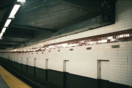
The station has four tracks and two island platforms, typical for a four-track express station.[6] The outer track walls are made of tile and have a Pomegranate red band with a Tuscan red border. Small black signs with "UTICA" in white lettering run below the bands at regular intervals. The station's i-beam columns are painted maroon. The station has been renovated with new old-fashioned light fixtures with modern sodium-vapor lamps in them. They are suspended on long rods from the high, vaulted ceilings.
This station has two fare control areas, one at either end. The full-time side at the eastern (railroad south) end has two staircases from each platform going up to a crossover (the western ones go up to a ramp that leads to the main fare control area), where a turnstile bank and two exit-only turnstiles provide access to and from the station. Outside fare control, there is a token booth and two street stairs, each going to either western corners of Utica Avenue and Fulton Street. The station's other fare control area has two staircases going down to each platform, a crossover, part-time turnstile bank and customer assistance booth, high entry/exit turnstiles that provide full-time access to and from the station, and two staircases going up to either side of Fulton Street between Stuyvesant and Schenectady Avenues.
Unusually, there are two mezzanine levels; the upper mezzanine level was closed off after a 1995 renovation, and the lower mezzanine level is actually the platform level of the unbuilt Utica Avenue line.
Between this station and Ralph Avenue, there is a fifth track between the express tracks, which could be used for storage or turning trains, although it is not normally used. The storage/layup tracks ends with bumper blocks on both ends, with a switch to the northbound express track on its west end and a switch to the southbound express track on the east end.[7][6]
Artwork here was made in 1996 by Jimmy James Green and is called Children's Cathedral.
Unfinished station
The center of the station slopes down and there is a lowered ceiling compared to the rest of the station.[8] Above is a disused portion of a mezzanine and an unfinished upper level station. The tracks are outlined by a pattern in the ceiling on top of the four trackways at the Utica Avenue station; therefore it appears that there are four trackways and two island platforms running diagonally across the ceiling in the center.[9] The unfinished upper level station was to be built for a subway line down Utica Avenue as part of the IND Second System.[10]
There were blocked stairways up from the platform level to the upper level that were removed during the station's renovation. Climbing the steps to the intermediate level, there are locked doors that serve as access to the unfinished platforms. There are also some windows in this level. Looking into the window reveals a cinder-block wall that were erected to prevent glimpses into the closed portion of the intermediate level mezzanine. Climbing the ramp to the entrance level reveals more windows and doors These doors provide access to the disused portion of the upper level mezzanine, which has steps leading to the disused portion of the intermediate level mezzanine (which in turn leads directly to the unfinished station).
Before the renovation of this station in 1995, it was possible to see the unfinished station from the mezzanine. In the intermediate level of the mezzanine, the closed section of the mezzanine was blocked only by a chain-link fence. Past the fence, there was a tiled wall with a door. The door had some panels missing, and whenever open, a look into the door revealed the unfinished upper level station. After the 1990s renovation of the Utica Avenue station, the mezzanine was shortened using cinder-block walls and the current tiling in the intermediate level, hiding the chain-link fence and the door behind it.
Exits

This station is compliant with the 1990 Americans With Disabilities Act. In May 2014, MTA installed three elevators: one near the intersection of Utica Avenue and Fulton Street, connecting the mezzanine to the street, and two elevators connecting the platforms to the mezzanine.[11]
There are four stair entrances, all on Fulton Street:[12]
- South side of Fulton Street west of Utica Avenue, at Boys and Girls High School[12]
 North side of Fulton Street west of Utica Avenue (staircase and elevator)[12]
- South side of Fulton Street west of Stuyvesant Avenue[12]
- North side of Fulton Street west of Stuyvesant Avenue[12]
In popular culture
This station's mezzanine and exterior can be seen in various points of 6ix9ine’s music video for the song "Kooda".
References
- ^ "Glossary". Second Avenue Subway Supplemental Draft Environmental Impact Statement (SDEIS) (PDF). Vol. 1. Metropolitan Transportation Authority. March 4, 2003. pp. 1–2. Archived from the original (PDF) on February 26, 2021. Retrieved January 1, 2021.
- ^ a b "NEW SUBWAY LINK OPENED BY MAYOR; He Tells 15,000 in Brooklyn It Will Be Extended to Queens When Red Tape Is Cut". The New York Times. April 9, 1936. ISSN 0362-4331. Retrieved August 15, 2016.
- ^ a b "Annual Subway Ridership (2018–2023)". Metropolitan Transportation Authority. 2023. Retrieved April 20, 2024.
- ^ "Annual Subway Ridership (2018–2023)". Metropolitan Transportation Authority. 2023. Retrieved April 20, 2024.
- ^ New York Times, Last Train is Run on Fulton St. 'El', June 1, 1940
- ^ a b Dougherty, Peter (2006) [2002]. Tracks of the New York City Subway 2006 (3rd ed.). Dougherty. OCLC 49777633 – via Google Books.
- ^ Marrero, Robert (January 1, 2017). "472 Stations, 850 Miles" (PDF). B24 Blog, via Dropbox. Retrieved April 27, 2018.
- ^ http://www.columbia.edu/~brennan/abandoned/Utica.ceil2.jpg
- ^ https://www.youtube.com/watch?v=2uAiSUML2YE
- ^ http://ltvsquad.com/Locations/urbanexploration.php?ID=187
- ^ "Utica Av AC Station Becomes the 82nd Fully ADA Accessible Subway Station". MTA. May 23, 2014.
- ^ a b c d e "MTA Neighborhood Maps: Crown Heights" (PDF). Metropolitan Transportation Authority. 2016. Retrieved July 5, 2016.
External links
- nycsubway.org – IND Fulton: Utica Avenue
- nycsubway.org — Children's Cathedral Artwork by Jimmy James Green (1996)
- Station Reporter — A Lefferts
- Station Reporter — A Rockaway
- Station Reporter — C Train
- Abandoned Stations: IND Second System unfinished stations
- The Subway Nut — Utica Avenue Pictures
- MTA's Arts For Transit — Utica Avenue (IND Fulton Street Line)
- Utica Avenue entrance from Google Maps Street View
- Stuyvesant Avenue entrance from Google Maps Street View
- Platforms from Google Maps Street View
| Fulton St. Line |
|
|---|---|
| |