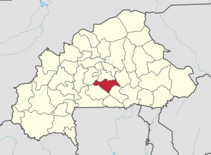
Bazèga Province
Appearance
Bazèga | |
|---|---|
Province | |
 Location in Burkina Faso | |
 Provincial map of its departments | |
| Country | |
| Region | Centre-Sud Region |
| Capital | Kombissiri |
| Area | |
| • Total | 1,530 sq mi (3,963 km2) |
| Population (2006) | |
| • Total | 238,202 |
| Time zone | UTC+0 (GMT 0) |
Bazèga is one of the 45 provinces of Burkina Faso and is in Centre-Sud Region. The capital of Bazèga is Kombissiri. In 2006 the population of Bazèga was 238,202[1] and in 2011 it was estimated to be 263,603.[2]
Education
In 2011 the province had 187 primary schools and 23 secondary schools.[2]
Healthcare
In 2011 the province had 37 health and social promotion centers (Centres de santé et de promotion sociale), 7 doctors and 109 nurses.[2]
Departments
Bazèga is divided into 7 departments:
| Commune | Capital | Population Census 2006)[1] |
|---|---|---|
| Doulougou Department | Doulougou | 26,738 |
| Gaongo Department | Gaongo | 25,753 |
| Ipelce Department | Ipelce | 13,182 |
| Kayao Department | Kayao | 33,994 |
| Kombissiri Department | Kombissiri | 66,342 |
| Saponé Department | Saponé | 38,958 |
| Toece Department | Toece | 33,265 |
See also
References
- ^ a b "National 2006 census preliminary results" (PDF). Archived from the original (PDF) on 2015-07-21. Retrieved 2007-12-20.
- ^ a b c "La région du Centre-Sud en chiffres" (PDF). Institut National de la Statistique et de la Démographie (INSD). 2011. p. 6. Archived from the original (PDF) on 2012-11-13.
12°04′01″N 1°20′12″W / 12.06694°N 1.33667°W
