Forest Glen Park, Maryland
Forest Glen Park, Maryland | |
|---|---|
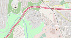
 Location map of Forest Glen Park | |
| Coordinates: 39°00′41″N 77°03′33″W / 39.0114986°N 77.0591441°W | |
| Country | United States |
| State | Maryland |
| County | Montgomery |
| Time zone | UTC-5 (Eastern (EST)) |
| • Summer (DST) | UTC-4 (EDT) |
| GNIS feature ID | 590215 |
Forest Glen Park is an unincorporated community and populated place in Montgomery County, Maryland,[1] and a neighborhood of Silver Spring. This quaint, leafy neighborhood's history dates back to between 1891 and the early twentieth century when the area developed alongside the adjoining National Park Seminary.
Geography and setting
Forest Glen Park is located within the forested hills to the immediate east of Rock Creek and Rock Creek Park.[1][2] The neighborhood is bound by the Forest Glen Creek valley and the Capital Beltway to its north, the historic National Park Seminary to its east, the Forest Glen Annex United States Army installation to its south east, and Rock Creek Park to its west and south.[1][2] Forest Glen Park is located approximately 1.4 miles (2.3 km) southeast of Kensington, approximately 1.9 miles (3.1 km) northwest of Downtown Silver Spring, and approximately 2.7 miles (4.3 km) northeast of Bethesda.[2]
References
- ^ a b c Geographic Names Information System, United States Geological Survey. "Geographic Names Information System: Feature Detail Report for Forest Glen Park (Feature ID: 590215)". Retrieved 20 June 2020.
- ^ a b c Kensington Quadrangle – Maryland (Map). 1:24,000. 7.5 Minute Series (Topographic). United States Geological Survey. 2019. OCLC 777258940. Archived from the original on 20 June 2020.

