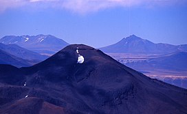
Vallecitos (volcano)
| Vallecitos | |
|---|---|
 Vallecitos is the distant conical mountain on the right. Seen from near Ojos del Salado | |
| Highest point | |
| Elevation | 6,120 m (20,080 ft)[1] |
| Prominence | 1,190 metres (3,904 ft) |
| Parent peak | Sierra Nevada de Lagunas Bravas |
| Coordinates | 26°12′39.95″S 068°19′00.48″W / 26.2110972°S 68.3168000°W |
| Geography | |
| Countries | Argentina |
| Parent range | Puna de Atacama, Andes |
| Climbing | |
| First ascent | 14/04/1999 - Henri Barret (France)[2] |
Vallecitos is a mountain subrange/area in Argentina. It has a height of 6,120 metres (20,079 ft). It is located at Antofagasta de la Sierra, Catamarca Province, at the Puna de Atacama.[3]
First ascent
Vallecitos was first climbed by Henri Barret (France) in 14/04/1999.[2] Also, Vallecitos has evidence of pre-Columbian ascents.
Elevation
Based on the elevation provided by the available Digital elevation models, SRTM (6097m[4]), ASTER (6079m[5]), SRTM filled with ASTER (6097m[6]), ALOS (6079m[7]), TanDEM-X(6138m[8]), Vallecitos is about 6120 meters above sea level.[9][10]
The height of the nearest key col is 4930 meters).[11] so its prominence is 1190 meters. Vallecitos is listed as mountain subrange or area, based on the Dominance system [12] and its dominance is 19.44%. Its parent peak is Sierra Nevada de Lagunas Bravas and the Topographic isolation is 39.4 kilometers. [13] This information was obtained during a research by Suzanne Imber in 2014.[14]
References
- ^ "Vallecitos". Andes Specialists. Retrieved 2020-04-12.
- ^ a b "AAJ". AAJ: 277. 2005.
- ^ "Capas SIG | Instituto Geográfico Nacional". www.ign.gob.ar. Retrieved 2020-04-30.
- ^ USGS, EROS Archive,. "USGS EROS Archive - Digital Elevation - SRTM Coverage Maps". Retrieved 12 April 2020.
{{cite web}}: CS1 maint: extra punctuation (link) CS1 maint: multiple names: authors list (link) - ^ "ASTER GDEM Project". ssl.jspacesystems.or.jp. Retrieved 2020-04-14.
- ^ "ASTER GDEM Project". ssl.jspacesystems.or.jp. Retrieved 2020-04-14.
- ^ "ALOS GDEM Project". www.eorc.jaxa.jp. Retrieved 2020-04-14.
- ^ TanDEM-X, TerraSAR-X. "Copernicus Space Component Data Access". Retrieved 12 April 2020.
- ^ "Andean Mountains - All above 5000m". Andes Specialists. Retrieved 2020-04-12.
- ^ "Vallecitos". Andes Specialists. Retrieved 2020-04-12.
- ^ "Andean Mountains - All above 5000m". Andes Specialists. Retrieved 2020-04-12.
- ^ "Dominance - Page 2". www.8000ers.com. Retrieved 2020-04-12.
- ^ "Vallecitos". Andes Specialists. Retrieved 2020-04-12.
- ^ ap507. "Academic and adventurer describes the incredible task of climbing and cataloguing one of the most remote regions of the South American Andes mountains — University of Leicester". www2.le.ac.uk. Retrieved 2020-04-12.
{{cite web}}: CS1 maint: numeric names: authors list (link)

