Liberec District
Liberec District
Okres Liberec | |
|---|---|
 | |
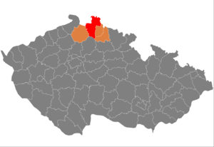
 District location in the Liberec Region within the Czech Republic | |
| Country | |
| Region | Liberec |
| Capital | Liberec |
| Area | |
| • Total | 988.87 km2 (381.80 sq mi) |
| Population (2019-01-01[1]) | |
| • Total | 174,811 |
| • Density | 180/km2 (460/sq mi) |
| Time zone | UTC+1 (CET) |
| • Summer (DST) | UTC+2 (CEST) |
| Municipalities | 59 |
| * Cities and towns | 11 |
| * Market towns | 1 |
| * Villages | 47 |
Liberec District (Czech: okres Liberec) is the district (okres) within the Liberec Region of Czech Republic. As its name implies, its administrative center is the city of Liberec.
Complete list of municipalities
Bílá - Bílý Kostel nad Nisou - Bílý Potok - Bulovka - Černousy - Český Dub - Cetenov - Chotyně - Chrastava - Čtveřín - Dětřichov - Dlouhý Most - Dolní Řasnice - Frýdlant - Habartice - Hejnice - Heřmanice - Hlavice - Hodkovice nad Mohelkou - Horní Řasnice - Hrádek nad Nisou - Jablonné v Podještědí - Janovice v Podještědí - Janův Důl - Jeřmanice - Jindřichovice pod Smrkem - Kobyly - Krásný Les - Křižany - Kryštofovo Údolí - Kunratice - Lázně Libverda - Lažany - Liberec - Mníšek - Nová Ves - Nové Město pod Smrkem - Oldřichov v Hájích - Osečná - Paceřice - Pěnčín - Pertoltice - Příšovice - Proseč pod Ještědem - Radimovice - Raspenava - Rynoltice - Šimonovice - Soběslavice - Stráž nad Nisou - Světlá pod Ještědem - Svijanský Újezd - Svijany - Sychrov - Višňová - Vlastibořice - Všelibice - Žďárek - Zdislava
References
- ^ "Population of municipalities of the Czech republic". Czech Statistical Office. Retrieved 2019-04-30.
50°46′1″N 15°3′22″E / 50.76694°N 15.05611°E
