Barbaraville
Barbaraville
| |
|---|---|
 | |
Location within the Highland council area | |
| OS grid reference | NH742706 |
| Council area | |
| Lieutenancy area |
|
| Country | Scotland |
| Sovereign state | United Kingdom |
| Post town | Invergordon |
| Postcode district | IV18 0 |
| Dialling code | 01862 |
| Police | Scotland |
| Fire | Scottish |
| Ambulance | Scottish |
| UK Parliament |
|
| Scottish Parliament |
|
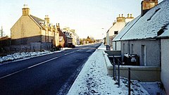
Barbaraville (Template:Lang-gd) is a small settlement on the north shore of Nigg Bay[1] in the Cromarty Firth in the Highland council area of Scotland.[2] Housing dates from 1820 on when local people were allowed to build on packets of land from local estates at Balnagown, Tarbet and Polnicol. Comprising approximately 170 households, there has been recent expansion with the creation of a retirement village at Highland Park which has added some 50 households to the community all of which are occupied by people over the age of 55.[citation needed]
Mull Hall [3] was originally the Jackdaw Hotel, and its restaurant and bar was a popular nightspot during the 1970s. It is now a residential home for the elderly. Barbaraville has a small shop at Highland Park, a telephone kiosk and post box, and has stops on the X25 Inverness - Dornoch bus route. The Green Wellie garden centre opened in 2012 [4]
The nearest small towns are Tain to the north east and Invergordon to the west.
It is in the Tain and Easter Ross Highland Council Ward and the Kilmuir and Logie Easter Community Council Area [5]
References
- ^ "Geograph:: Approaching Barbaraville - Nigg Bay (C) Nick R". www.geograph.org.uk. Retrieved 4 December 2019.
- ^ Microsoft; Nokia. "Barbaraville" (Map). Bing Maps. Microsoft. Retrieved 20 April 2017.
- ^ "Archived copy". Archived from the original on 22 May 2013. Retrieved 28 March 2013.
{{cite web}}: CS1 maint: archived copy as title (link) - ^ https://www.facebook.com/TheGreenWellie
- ^ http://www.kalecc.org.uk

