Flémalle
Appearance
Flémalle | |
|---|---|
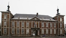
 Town hall | |
| Coordinates: 50°36′N 05°28′E / 50.600°N 5.467°E | |
| Country | |
| Community | French Community |
| Region | Wallonia |
| Province | Liège |
| Arrondissement | Liège |
| Government | |
| • Mayor | Isabelle Simonis (PS) |
| • Governing party/ies | PS |
| Area | |
| • Total | 36.57 km2 (14.12 sq mi) |
| Population (2018-01-01)[1] | |
| • Total | 26,174 |
| • Density | 720/km2 (1,900/sq mi) |
| Postal codes | 4400 |
| NIS code | 62120 |
| Area codes | 04 |
| Website | www.flemalle.be |
Flémalle (Template:Lang-wa) is a Walloon municipality located in the Belgian province of Liège. On January 1, 2006, Flémalle had a total population of 25,140. The total area is 36.68 km² which gives a population density of 685 inhabitants per km².
Places
- Awirs (pop: 2,869)
- Chokier (Walloon: Tchôkire)
- Flémalle-Grande (Walloon: Li Grande Flémåle)
- Flémalle-Haute (Walloon: Li Hôte Flémåle)
- Gleixhe
- Ivoz-Ramet
- Mons-lez-Liège
Other places
Population history
| Year | Population | Density |
|---|---|---|
| 2002 | 25,001 | 696.94/km² |
| 2004 | 25,259 | 668.29/km² |
| 2005 | 25,193 | 686.79/km² |
Twinnings
See also
- List of protected heritage sites in Flémalle
- Robert Campin, a painter (14th century), also known as "Le maître de Flémalle" (The Master of Flémalle)
- André Cools, a Belgian politician who was nicknamed "Le maître de Flémalle" (Flémalle's master).
References
- ^ "Wettelijke Bevolking per gemeente op 1 januari 2018". Statbel. Retrieved 9 March 2019.
External links
 Media related to Flémalle at Wikimedia Commons
- Official website (in French)
- Site du club d'aïkido de Flémalle (in French)
- Perspectives – Organisme d'insertion socio professionnel à Flémalle (in French)


