Kings Meadows, Tasmania
Appearance
| Kings Meadows Launceston, Tasmania | |||||||||||||||
|---|---|---|---|---|---|---|---|---|---|---|---|---|---|---|---|
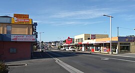
 View south down Hobart Road through Kings Meadows | |||||||||||||||
| Population | 3,670 (2016 census)[1] | ||||||||||||||
| Postcode(s) | 7249 | ||||||||||||||
| Location | 4 km (2 mi) from Launceston, Tasmania | ||||||||||||||
| LGA(s) | City of Launceston | ||||||||||||||
| State electorate(s) | Bass | ||||||||||||||
| Federal division(s) | Bass | ||||||||||||||
| |||||||||||||||
King's Meadows is a suburb in the south of Launceston, Tasmania, Australia. Kings Meadows is located in the floor of a shallow valley, roughly 70m above sealevel, which drains NE towards the small suburb of Punchbowl. Main access to the suburb from the CBD is from Hobart Road via the minor suburb of Sixways. Kings Meadows High School is located in this suburb.
References
- ^ Australian Bureau of Statistics (27 June 2017). "Kings Meadows (State Suburb)". 2016 Census QuickStats. Retrieved 6 December 2017.
41°28′14″S 147°09′47″E / 41.47056°S 147.16306°E
