Băicoi
Appearance
Băicoi | |
|---|---|
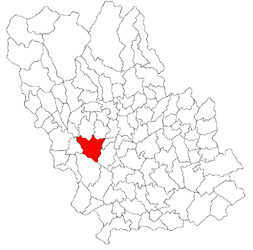
 Location in Prahova County | |
| Coordinates: 45°2′43″N 25°51′57″E / 45.04528°N 25.86583°E | |
| Country | Romania |
| County | Prahova |
| Government | |
| • Mayor | Ciprian Stătescu[1] (PNL) |
| Area | 65.36 km2 (25.24 sq mi) |
| Population (2021-12-01)[2] | 16,722 |
| • Density | 260/km2 (660/sq mi) |
| Time zone | EET/EEST (UTC+2/+3) |
| Vehicle reg. | PH |
| Website | primariabaicoi |
Băicoi (Romanian pronunciation: [bəjˈkoj]) is a town in Prahova county, Romania, near the 45th parallel. It lies near Florești, a train stop between Ploiești and Câmpina. Five localities are administered by the town: Dâmbu, Liliești, Schela, Tufeni and Țintea. Over time, these have become neighborhoods of the town.[3] Bӑicoi is situated in the historical region of Muntenia.
History
| Year | Pop. | ±% |
|---|---|---|
| 1956 | 8,287 | — |
| 1966 | 9,120 | +10.1% |
| 1977 | 17,440 | +91.2% |
| 1992 | 20,681 | +18.6% |
| 2002 | 20,020 | −3.2% |
| 2011 | 17,981 | −10.2% |
| Source: Census data | ||
Its name is derived from "Baicu".
Notes
- ^ "Results of the 2016 local elections". Central Electoral Bureau. Retrieved 5 April 2020.
- ^ "Populaţia rezidentă după grupa de vârstă, pe județe și municipii, orașe, comune, la 1 decembrie 2021" (XLS). National Institute of Statistics.
- ^ (in Romanian) "Population" Archived 2015-07-22 at the Wayback Machine at the Băicoi Town Hall site; accessed March 15, 2013
External links
Wikimedia Commons has media related to Băicoi.


