Vrsar
This article needs additional citations for verification. (May 2010) |
You can help expand this article with text translated from the corresponding article in Croatian. (May 2020) Click [show] for important translation instructions.
|
Vrsar/Orsera | |
|---|---|
Municipality | |
| Vrsar/Orsera Municipality Općina Vrsar - Comune di Orsera[1] | |
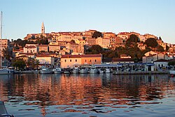
 Vrsar old harbor | |
| Coordinates: 45°09′N 13°36′E / 45.150°N 13.600°E | |
| Country | |
| County | Istria |
| Government | |
| • Major | Franko Štifanić (IDS) |
| Population (2011)[2] | |
| • Total | 2,162 |
| Time zone | UTC+1 (CET) |
| • Summer (DST) | UTC+2 (CEST) |
| Website | www |
Vrsar (Venetian: Orsera) is a small town and a municipality in Istria, Croatia located 9 kilometers south of Poreč.[3][4]
History
Vrsar was part of the Republic of Venice (1420-1797), then of the French Kingdom of Italy firstly, and Illyrian Provinces till 1814. After the fall of Napoleon, it was part of the Austrian Littoral up to 1915 then became part of Kingdom of Italy (1918–1947) after which it was part of Yugoslavia until 1991 when incorporated in the Republic of Croatia.[5]
References
- ^ "Statut općine Vrsar" (PDF) (in Croatian). 28 June 2013. Retrieved 26 May 2020.
- ^ "Population by Age and Sex, by Settlements, 2011 Census: Vrsar". Census of Population, Households and Dwellings 2011. Zagreb: Croatian Bureau of Statistics. December 2012.
- ^ "Vrsar - tourist guide". Adriagate. Retrieved 2019-12-15.
- ^ Sinke (2016-09-12). "Three Reasons to Visit Vrsar". Croatia Times. Archived from the original on 2019-12-15. Retrieved 2019-12-15.
- ^ "Vrsar - Travel guide for tourists in Istria, Croatia". Istria Sun. Retrieved 2019-12-15.
Wikimedia Commons has media related to Vrsar.


