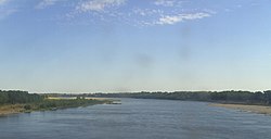
Akhtuba

The Akhtuba (Russian: А́хтуба); also transliterated Achtuba on some maps) is a left distributary of the Volga in southern Russia.[1]
The Akhtuba splits off the Volga above the city Volgograd (at 48°49′00″N 44°41′17″E / 48.8167°N 44.6880°E), and flows toward the Volga Delta and Caspian Sea. The old beginning of Akhtuba was blocked by the dam of the Volga Hydroelectric Station; now it flows from the Volga via an artificial outtake canal 6.5 kilometres (4.0 mi) long that starts below the dam. The river is 537 kilometres (334 mi) long; the average water flow is 153 cubic metres per second (5,400 cu ft/s).
The following cities lie on or near the Akhtuba: Volzhsky (at the beginning of the river), Leninsk, Znamensk, Akhtubinsk, Kharabali (within 5 kilometres of the river). The capital of the Golden Horde, Sarai Batu, was most likely located along the Akhtuba as well, not far from Kharabali.[citation needed]
The area between the Volga and the Akhtuba is known as the Volga-Akhtuba plain, which is one of Russia's primary vegetable growing areas. It is particularly well known as a major source of watermelons consumed in Russia.
References
- ^ Golosov, V.; Belyaev, V.; Walling, D.E. (2004). Sediment Transfer Through the Fluvial System: Proceedings of the International Symposium Held at Moscow, Russia, from 2 to 6 August, 2004. IAHS publication. IAHS. p. 303. ISBN 978-1-901502-67-1.

