Teyvaz
Appearance
Teyvaz | |
|---|---|
Municipality | |
| Coordinates: 39°15′19″N 45°46′17″E / 39.25528°N 45.77139°E | |
| Country | |
| Autonomous republic | Nakhchivan |
| Rayon | Julfa |
| Population (2005)[citation needed] | |
| • Total | 350 |
| Time zone | UTC+4 (AZT) |
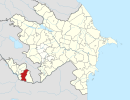
Teyvaz is a village and municipality in the Julfa Rayon of Nakhchivan, Azerbaijan. It is located 57 km in the north from the district center, on the right bank of the Alinjachay River, on the slope of the Zangezur ridge. Its population is busy with farming and animal husbandry. There are secondary school, club, library, kindergarten and a medical center in the village. It has a population of 350.[1]
Etymology
According to some[who?] researchers, the name of the village derives from the words taipa (wide) and az (valley) from ancient Turkic languages, meaning "the founded settlement in the vast valley located between the big watershed, hills and rivers".[2]
References
- ^ ANAS, Azerbaijan National Academy of Sciences (2005). Nakhchivan Encyclopedia. Vol. volume II. Baku: ANAS. p. 326. ISBN 5-8066-1468-9.
{{cite book}}:|volume=has extra text (help) - ^ Encyclopedic Dictionary of Azerbaijan Toponyms. In two volumes. Volume I. p. 304. Baku: "East-West". 2007. ISBN 978-9952-34-155-3.


