Kharanaq
Kharanaq
خرانق | |
|---|---|
village | |
 | |
| Coordinates: 32°20′46″N 54°39′57″E / 32.34611°N 54.66583°E | |
| Country | |
| County | Ardakan |
| Bakhsh | Kharanaq |
| Rural District | Rabatat |
| Population (2006) | |
| • Total | 433 |
| Time zone | UTC+3:30 (IRST) |
| • Summer (DST) | UTC+4:30 (IRDT) |
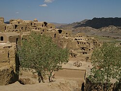
Kharanaq (Persian: خرانق, also Romanized as Kharānaq, Kharāneq, and Kharānoq; also known as Khowrāneq and ((means land of sun))Khurūnaq)[1] is a village in Rabatat Rural District, Kharanaq District, Ardakan County, Yazd Province, Iran. At the 2006 census, its population was 433, in 133 families. The town and its minaret have become a minor tourist attraction.[2] Kharanaq, which was known as a world and historical village, was introduced as the 23rd city of Yazd province on July 6, 2020.[3] Driving 70 k.m to the north of Yazd, we reach Kharanagh/ Kharanaq. This 4500-year-old city is surrounded by mountains on one side and desert from the other. Many buildings in Kharanaq/ Kharanagh are completely collapsed and ramshackle, but among them, the remaining mosque from the Qajar period, a shaking minaret from 17th and the caravanserai of the city have been reconstructed and can be visited.[4]
References
- ^ Kharanaq can be found at GEOnet Names Server, at this link, by opening the Advanced Search box, entering "-3070691" in the "Unique Feature Id" form, and clicking on "Search Database".
- ^ "Kharānaq". Atlas Obscura. Retrieved 2019-05-02.
- ^ "Kharanaq".
- ^ "Kharanaq, Chak Chak and Meybod".

