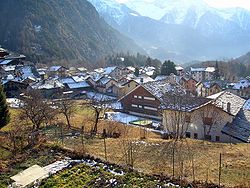
Brusson, Aosta Valley
Appearance
Brusson | |
|---|---|
| Comune di Brusson Commune de Brusson | |
 | |
| Coordinates: 45°46′N 7°44′E / 45.767°N 7.733°E | |
| Country | Italy |
| Region | Aosta Valley |
| Province | none |
| Frazioni | Pasquier, La Croix, Vollon, Estoul, La Pilaz, Arcésaz, Extrepierre, Fontaine, Graines, Curien, Fénille |
| Government | |
| • Mayor | Giulio Grosjacques |
| Area | |
| • Total | 55 km2 (21 sq mi) |
| Elevation | 1,338 m (4,390 ft) |
| Population (31 July 2010)[2] | |
| • Total | 859 |
| • Density | 16/km2 (40/sq mi) |
| Demonym | Brussonins |
| Time zone | UTC+1 (CET) |
| • Summer (DST) | UTC+2 (CEST) |
| Postal code | 11022 |
| Dialing code | 0125 |
| Patron saint | Saint Maurice |
| Saint day | 22 September |
| Website | Official website |
Brusson (Valdôtain: Breutson; Issime Walser: Brütze; Gressoney Walser: Britze) is a town and comune in Val d'Ayas, a left minor valley of the Aosta Valley region in Italy.
It is well known as a summer and winter vacationing spot, and better known for its plentiful cross-country skiing trails. It is also a good starting point for climbing Monte Rosa. Brusson is part of the Monterosa Ski domain, home to cross-country skiing trails used for several World Cup races.
Sights include the medieval Graines Castle.
Twin towns
 Forio, Italy (2008)
External links
![]() Media related to Brusson (Italy) at Wikimedia Commons
Media related to Brusson (Italy) at Wikimedia Commons
- ^ "Superficie di Comuni Province e Regioni italiane al 9 ottobre 2011". Italian National Institute of Statistics. Retrieved 16 March 2019.
- ^ "Popolazione Residente al 1° Gennaio 2018". Italian National Institute of Statistics. Retrieved 16 March 2019.


