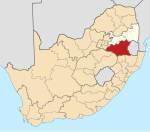
Daggakraal
Daggakraal | |
|---|---|
| Coordinates: 27°07′01″S 29°58′01″E / 27.117°S 29.967°E | |
| Country | South Africa |
| Province | Mpumalanga |
| District | Gert Sibande |
| Municipality | Pixley Ka Seme |
| Area | |
• Total | 64.43 km2 (24.88 sq mi) |
| Population (2011)[1] | |
• Total | 17,378 |
| • Density | 270/km2 (700/sq mi) |
| Racial makeup (2011) | |
| • Black African | 99.3% |
| • Coloured | 0.1% |
| • Indian/Asian | 0.3% |
| • White | 0.1% |
| • Other | 0.1% |
| First languages (2011) | |
| • Zulu | 90.7% |
| • Swazi | 4.0% |
| • Sotho | 2.5% |
| • Other | 2.8% |
| Time zone | UTC+2 (SAST) |
Daggakraal, "one of South Africa's most impoverished and isolated communities with plenty of mineral resources",[2] is a town in Gert Sibande District Municipality near Volksrust in the Mpumalanga province of South Africa.[3] The town had about 1,450 households in 2014.[4]
Founding
Pixley Ka Isaka Seme, President of the African National Congress from 1930 to 1936, was born in Durban in 1881.[3][5] In 1911, he established the "South African Native Farmers Association" in order to encourage black farm labourers from the Free State to buy land in the area and become commercial farmers themselves, and thus to attain personal independence. This initiative led to the settling of Daggakraal in 1912,[4] and so worried the white government that it formulated and enacted the Natives Land Act of 1913, barring black people from owning land in South Africa.[2] However, the black farmers who had bought property in Daggakraal retained the land they had purchased. These farmers later rented residential stands to families that relocated from the Eastern Transvaal.[4] Seme owned two farms in the area.[2]
Post-apartheid
In 1997, a piggery, grain and livestock farm was handed to the community as part of South Africa's land reform programme. As a result of infighting amongst the beneficiaries and misappropriation of funds, the bequests are now unproductive. A soccer stadium which began construction in 1991 was never completed due to embezzlement.[4]
A statue of Seme was erected and unveiled in the town on 31 March 2012.[5]
References
- ^ a b c d "Main Place Daggakraal". Census 2011.
- ^ a b c Yende, Sizwe Sama (2004-01-12). "Struggle hero honoured". News24. Retrieved 2017-05-15.
- ^ a b "Pixley Ka Seme Local Municipality". Archived from the original on 2017-10-03. Retrieved 2017-05-15.
- ^ a b c d Yende, Sizwe Sama (2014-06-05). "Going home 20 years later: Everything–and nothing–changes". News24. Retrieved 2017-05-15.
- ^ a b "Pixley Ka Seme stature unveiled". South African Broadcasting Corporation. 2012-03-31. Archived from the original on 2017-08-20. Retrieved 2017-05-15.


