
Bonnievale, South Africa
Bonnievale | |
|---|---|
 Church street in Bonnievale | |
 Bonnievale  Bonnievale | |
| Coordinates: 33°55′39″S 20°6′2″E / 33.92750°S 20.10056°E | |
| Country | South Africa |
| Province | Western Cape |
| District | Cape Winelands |
| Municipality | Langeberg |
| Area | |
| • Total | 27.07 km2 (10.45 sq mi) |
| Population (2011)[1] | |
| • Total | 9,092 |
| • Density | 340/km2 (870/sq mi) |
| Racial makeup (2011) | |
| • Black African | 11.1% |
| • Coloured | 75.3% |
| • Indian/Asian | 0.2% |
| • White | 10.7% |
| • Other | 2.7% |
| First languages (2011) | |
| • Afrikaans | 89.7% |
| • Xhosa | 6.0% |
| • English | 1.7% |
| • Sotho | 1.3% |
| • Other | 1.3% |
| Time zone | UTC+2 (SAST) |
| Postal code (street) | 6730 |
| PO box | 6730 |
| Area code | 023 |
Bonnievale is a settlement in Cape Winelands District Municipality in the Western Cape province of South Africa.
Town 64km south-east of Worcester, in the Breede River Valley. Founded in 1922 and named after the railway siding which had been called Vale since its opening in 1902 and Bonnie Vale in 1917. Municipal status was gained in April 1953.[2]
Gallery
-
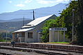
Old station building, 1922 – 2012 -
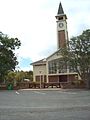
NG Church, built c. 1922 -

DJ le Roux Museum -

Weltevrede vineyards


References
- ^ a b c d "Main Place Bonnievale". Census 2011.
- ^ "Dictionary of Southern African Place Names (Public Domain)". Human Science Research Council. p. 89.
Municipalities and communities of Cape Winelands District Municipality, Western Cape | ||
|---|---|---|
District seat: Stellenbosch | ||
| Witzenberg | .svg) | |
| Drakenstein | ||
| Stellenbosch | ||
| Breede Valley | ||
| Langeberg | ||
This Western Cape location article is a stub. You can help Wikipedia by expanding it. |