
United Nations station (LRT)
United Nations | |||||||||||
|---|---|---|---|---|---|---|---|---|---|---|---|
 | |||||||||||
| General information | |||||||||||
| Location | Taft Avenue cor. General Luna St. and United Nations Avenue Ermita, Manila Philippines | ||||||||||
| Owned by | Department of Transportation Light Rail Manila Corporation | ||||||||||
| Line(s) | Lua error: expandTemplate: template "Manila MMRT color" does not exist. | ||||||||||
| Platforms | Side platforms | ||||||||||
| Tracks | 2 | ||||||||||
| Connections | Jeepneys, buses, taxis, cycle rickshaws | ||||||||||
| Construction | |||||||||||
| Structure type | Elevated | ||||||||||
| Parking | Yes (Times Plaza & The Pearl Manila) | ||||||||||
| Other information | |||||||||||
| Station code | UN | ||||||||||
| History | |||||||||||
| Opened | December 1, 1984 | ||||||||||
| Services | |||||||||||
| |||||||||||
| |||||||||||

United Nations station, also known as U.N. Avenue station, is a station on the Manila Light Rail Transit System Line 1. Like all other Line 1 stations, United Nations station is above-ground. The station serves Ermita in Manila and is located at the corner of Taft and United Nations Avenues. The station is named after United Nations Avenue, which in turn is named after the United Nations.
United Nations station serves as the thirteenth station for Line 1 trains headed for Baclaran and as the eighth station for trains headed to Roosevelt.
Transportation links
United Nations station is well-served by buses and jeepneys that serve the Taft Avenue and nearby routes. Taxis and cycle rickshaws also stop at and around the station.
Gallery
-
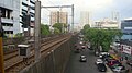 Overview of United Nations, Manila, from United Nations LRT station
 -
 The rails
 -
 Platform area, panoramic view


