Zhawar

Zhawar is an area within the Khost Province of Afghanistan.[a]
Zhawar Kili
Jalaluddin Haqqani was (is) known by Afghani mujahideen as master of the Zhawar Kili cave complex. (B.G. Williams 2013).[2]
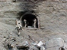
Mir Bahmanyar writes of the caves during 1986. He states there were caves carved into the rock face on the side facing Pakistan. The caves were ten metres long at the maximum, four metres wide and three metres tall. The cave sides had walls of brick. Altogether there were forty-one caves. The caves had doors of iron painted over with bright colours. All the caves were fitted with electrical power.[3]
Zhawar Kili is suspected to have been an area where al Qaeda fighters regrouped after the bombardment of Tora Bora and is located at 33.148792 N, 69.912658 E.
The Zhawar Kili al Badr training camp was based here during 2002.[2]


A statement published January 2002, showing the report of the deputy director of operations for the Joint Chiefs of Staff at the time, stated the site was a very large complex (approximately 4.8 by 4.8 kilometres square roughly).[4][5] Rear Adm. J.D. Stufflebeem stated of the Zhawar Kili al Badr training camp, that it contained at least sixty buildings and caves of a number greater than fifty.[6]
January 2002 saw the insertion of a supported Navy Seals team, who were positioned to perform reconnaissance. Upon discovering a complex of approximately seventy caves converted to facilities for ordnance, they instead proceeded to perform the destruction of this. At the location the men also found classrooms, rooms for cooking, quarters for sleep, and offices, which were constructed using bricks, concrete and steel beams.[7]
Bombing
The location is the site of a suspected Taliban or al Qaeda base that was bombed in 1998 and 2001.[8][9]
American cruise missiles bombed a suspected al Qaeda site in Zhawar Kili in 1998 in retaliation for the bombing of the American Embassies in Kenya and Tanzania in 1998.[8]
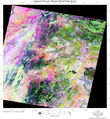
The United States Air Force performed bombings during 2001.[10] A bombing during November 2001, was indirectly caused by Richard A. Beck, a geologist at the University of Cincinnati who informed the Department of Defense he could identify the rocks showing within video footage of Osama bin Laden released during October 2001, from a field trip he had made to Khowst. Ascertainment of the location was facilitated by the utilization of GIS technology and remote sensing.[8][11]
During 2002, a period of bombing began, apparently, during the 3rd of January,[12] and included a period from the 6th to the 14th of January 2002.[13] The United States (of America) Department of Defense released a video of the bombardment of Zhawar Kili during March 2002.[14][15][16]
Gallery
Location from above
-
Zhawar Kili from a 1998 briefing
-
Zhawar Kili al Badr (West), circa 20th century
-
Zhawar Kili from a 2002 briefing
-
Zhawar Kili from a 2002 briefing
-
Zhawar Kili from a 2002 briefing
-
Landsat image of Zhawar Kili, in Khowst
See also
Notes
- ^ Until 1985, it was part of Paktia Province.[1]
References
- ^ Thomas Ruttig (2009). "Loya Paktia's Insurgency: The Haqqani Network as an Autonomous Entity" (PDF). p. 1. Retrieved 6 August 2020.
- ^ a b B.G. Williams 12 May 2013. work (PDF). published by Routledge - Taylor & Francis group. Retrieved 2015-11-12.
{{cite book}}: CS1 maint: numeric names: authors list (link) - ^ M. Bahmanyar - [1] published by Osprey Publishing April 20, 2012, 64 pages, ISBN 1780966296 [Retrieved 2015-11-23]
- ^ E. Schrader and E. Slater - article published by Los Angeles Times January 15, 2002 [Retrieved 2015-11-22]
- ^ John Dickson Stufflebeem - Pentagon Briefing: Zawar Kili Buildings Searched, Destroyed Aired January 14, 2002, published by CNN [Retrieved 2015-11-22]
- ^ E. Schrader and E. Slater - article published January 15, 2002 by the Los Angeles Times [Retrieved 2015-11-14]
- ^ H. Halberstadt - text published by Zenith Imprint, ISBN 161060766X [Accessed 2015-11-14]
- ^ a b c Marianne Kunnen-Jones (2002-10-30). "Scouting Out Al Queda: Researcher Develops New Methods of Counter-Terrorism". University of Cincinnati. Archived from the original on November 15, 2008. Retrieved 2008-11-15.
{{cite news}}: CS1 maint: bot: original URL status unknown (link) - ^ "DoD News Briefing - Gen. Myers". Department of Defense. Archived from the original on 2004-01-15. Retrieved 2008-11-15.
- ^ Caldwell, Douglas R.; Ehlen, Judy; Harmon, Russell S. (2007). Studies in Military Geography and Geology. Springer Science & Business Media. p. 302. ISBN 978-1-4020-3105-2.
- ^ Sloan, Stephen; Anderson, Sean K. (2009). Historical Dictionary of Terrorism. Scarecrow Press. p. 211. ISBN 978-0-8108-6311-8.
- ^ J.E. Pike (Director) (GlobalSecurity.org). report. GlobalSecurity.org. Retrieved 2015-11-22.
- ^ Headquarters of the U.S. Air force (Office of Lessons Learned - AF/XOL) (7 February 2005). Operation Anaconda An Air power perspective (document/AFD-140917-026.pdf) (PDF). Air Force Historical Studies Division. Retrieved 2015-11-21.
- ^ "DoD News Briefing - ASD PA Clarke and Rear Adm. Stufflebeem". published by United States (of America) Department of Defense. 2002-01-07. Archived from the original on November 15, 2008. Retrieved 2008-11-15.
{{cite news}}: CS1 maint: bot: original URL status unknown (link) - ^ "Building in Zhawar Kili Complex. (.mpg 3 MB) (020108-D-6570C-001)". published by United States (of America) Department of Defense. 2002-01-07. Archived from the original on November 15, 2008. Retrieved 2008-11-15.
- ^ "Building in Zhawar Kili Complex. (2.rm 1 MB) (020108-D-6570C-002)". published by United States (of America) Department of Defense. 2002-01-07. Retrieved 2008-11-15.
External links
- D.B. Edwards (1984) - text Ethnographic Fieldwork: An Anthropological Reader published by John Wiley & Sons, 24 Jan 2012


