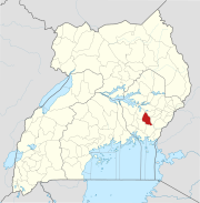
Namutumba, Uganda
Namutumba | |
|---|---|
| Coordinates: 00°50′06″N 33°41′06″E / 0.83500°N 33.68500°E | |
| Country | |
| Region | Eastern Region of Uganda |
| Sub-region | Busoga sub-region |
| District | Namutumba District |
| Elevation | 3,540 ft (1,080 m) |
| Population (2014 Census) | |
• Total | 18,736[1] |
Namutumba is a town in the Namutumba District of the Eastern Region of Uganda. It is the main municipal, administrative, and commercial centre of the district.
Location
Namutumba is approximately 88 kilometres (55 mi), by road, northeast of Jinja, the largest city in the sub-region.[2] This is approximately 43 kilometres (27 mi), by road, northeast of Iganga, the closest large town.[3] The town of Busembatya in Iganga District, about 13.5 kilometres (8.4 mi)[4] to the southwest of Namutumba, is the closest neighboring trading center and has the nearest post office. To the northeast of Namutumba is Tirinyi in Kibuku District, another small town on the main Iganga-Mbale road. The coordinates of Namutumba are 0°50'06.0"N, 33°41'06.0"E (Latitude:0.8350; Longitude:33.6850).[5]
Overview
The town of Namutumba is on the major highway between Iganga and Mbale, on the Tirinyi Bridge Road, which is known locally as the Tirinyi–Mbale Road. Namutumba is twinned with the town of Ross-on-Wye in Herefordshire, England.
Population
The 2002 national census estimated the population of Namutumba at 8,320. In 2010, the Uganda Bureau of Statistics (UBOS) estimated the population at 10,300. In 2011, UBOS estimated the population at 10,600.[6] In 2014, the national population census put the population at 18,736[1]
Points of interest
The following additional points of interest lie within the town limits or close to the edges of the town:
- offices of Namutumba Town Council
- Kisiki College
- Namutumba central market
- Namutumba Hospital[7]
- The Iganga-Mbale Road - The road goes through the middle of town.
See also
References
- ^ a b UBOS (29 November 2014). "The Population of The Regions of the Republic of Uganda And All Cities And Towns of More Than 15,000 Inhabitants". Citypopulation.de Quoting Uganda Bureau of Statistics (UBOS). Retrieved 27 February 2015.
- ^ "Road Distance Between Jinja And Namutumba With Map". Globefeed.com. Retrieved 28 May 2014.
- ^ "Map Showing Iganga and Namutumba with Distance Marker". Globefeed.com. Retrieved 28 May 2014.
- ^ "Road Distance Between Busembatya and Namutumba with Map". Globefeed.com. Retrieved 28 May 2014.
- ^ "Location of Nebbi At Google Maps" (Map). Google Maps. Retrieved 21 July 2015.
- ^ UBOS. "Estimated Population of Namutumba In 2002, 2010 & 2011". Uganda Bureau of Statistics (UBOS). Archived from the original (PDF) on 11 April 2019. Retrieved 28 May 2014.
- ^ Olaka, Denis (25 December 2012). "Two Bank Managers Killed in Fatal Accident On Christmas Eve". Kampala: Uganda Radio Network. Retrieved 27 February 2016.


