Grótta

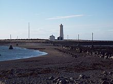
Grótta is a tied island at the extreme end of Seltjarnarnes in the Capital Region of Iceland. During high tide the tombolo is completely submerged, turning Grótta into an island.[1]
The island is accessible by foot during low tide, giving people a window of about six hours to visit the island.[2] Grótta and the region close by is a popular outdoor recreational area.[3]
Grótta became a nature reserve in 1974[1] and it is forbidden to visit it during nesting season, from 1 May to 15 July.[2] There are about 450 couples of arctic terns in Grótta.[1]
A lighthouse was originally built in 1897, a new one was built in 1947.[2] The local search and rescue association is named after long term lighthouse keeper Albert Þorvarðarson (1910–1973).[1]
The main house has been deserted since 1970.[2] The municipality acquired the buildings in 1994 and they are now used as occasional facilities for groups on school trips.[2]
References
- ^ a b c d "Grótta, Seltjarnarnesi". Environment Agency of Iceland (in Icelandic). Retrieved 28 July 2020.
{{cite web}}: CS1 maint: url-status (link) - ^ a b c d e "Grótta". Municipality of Seltjarnarnes. Retrieved 28 July 2020.
{{cite web}}: CS1 maint: url-status (link) - ^ "Grótta verði lokuð áfram". Morgunblaðið (in Icelandic). Retrieved 28 July 2020.
{{cite web}}: CS1 maint: url-status (link)
